Anacostia Park
Washington, DC | 2020 - 2021
Cultural Landscape Inventory
Project Team: Randall Mason, Molly Lester, Jacob Torkelson, Sarah Lerner, Xue Fei Lin
History
Although the area that encompassed the Anacostia Park cultural landscape did not exist as a permanent landscape until the 20th century, it is located in a region that has been inhabited by humans since at least 15,000 BCE (Louis Berger 2016: 6-8). English colonizer John Smith, who explored the Chesapeake watershed in 1608, recorded the location of a village near the mouth of the Anacostia River that he called Nacotchtank, meaning “at the trading town.” Other explorers quickly followed suit using Smith’s map, exacerbating tensions between Native American groups and White colonizers. Between 1608 and 1790, Europeans replaced Native Americans as the main inhabitants of land that would eventually become Washington, D.C. European plantations relied on enslaved labor to cultivate cash crops such as tobacco, which was transported to market along the navigable waterways of the Eastern Branch of the Potomac River (now known as the Anacostia River). However, by 1762, agricultural runoff rendered much of the Eastern Branch too shallow for navigation, blocking portions of the Navy Yard channel. Due to this, the nature of agriculture shifted away from the cash-crop model towards smaller plots, as many of the larger landowners sold off portions of their land.
As heightened construction and poor agricultural practices resulted in runoff and deforestation, the shoreline of the Anacostia River transformed over the 19th century into large areas of marshy wetlands, dense grasses, and accumulated waste (Gutheim and Lee 2006: 147). Given the sedimentation of portions of the Navy Yard channel and the Anacostia River’s associations with unsightly, unnavigable, and unhygienic conditions, engineers began designing for its reclamation. River improvements were underway by 1892, and continued in earnest after 1898, when Congress passed an act mandating the dredging of the Anacostia River. By the time the McMillan Plan of 1902 was published, District officials called for the construction of an "Anacostia Water Park” on the reclaimed banks of the river. Under such a plan, the river’s silt would be dredged and dumped on the Anacostia flats, after which the reclaimed land would be used for park purposes (Moore 1902: 105). “Anacostia Park” was officially named and established under an act of Congress in 1918.
Reclamation efforts in the early 20th century precipitated recreational improvements under the Office of Public Buildings and Grounds (OPBG). The design and planning for the new Anacostia Park in Section D of the cultural landscape was in progress by 1922-1923, under landscape architects Irwin W. Payne and Thomas C. Jeffers. While Payne and Jeffers drew up plans for Anacostia Park Section D, work continued on the reclamation and construction of parkland in other sections, including in Section E. The OPBG broke ground for Anacostia Park on August 2, 1923. Dredging and construction of the Anacostia Park cultural landscape was complete by 1924, with construction of seawalls north of the cultural landscape finished by 1927. In 1925, the U.S. Army Corps of Engineers transferred Section E to the Office of Public Buildings and Public Parks (successor agency of the OPBG) to become part of the evolving park.
Section D of Anacostia Park was specifically envisioned as a segregated, whites-only recreation area of a segregated Anacostia Park; Section C, meanwhile, was envisioned as the section of the park for Black visitors. As designed, the 11the Street Bridge would be the center of the park, dividing the two segregated sides. However, funding never materialized for the development of Section C, and much of it was given away to the District for tree nurseries. Despite the lack of recreational development in Section C, Payne wasted no time in further developing Section D of the cultural landscape. By 1930, Section D included a whites-only nine-hole golf course, numerous sports fields, and a large clubhouse.
With the onset of the Great Depression in 1929, much of the country became unemployed and impoverished. Desperation and disgruntlement grew, particularly among those veterans of the recent world war, who felt abandoned by their government. In May of 1932, thousands of unemployed World War I veterans and their families formed the Bonus Army, to march on Washington and demand early cash redemption of their service certificates promised by Congress. For weeks, the Bonus Army occupied the Anacostia flats in the unimproved Anacostia Park Section C. The temporary encampment consisted of impromptu shelters organized along a military grid. However, the Bonus Army camp was short-lived; after just a few weeks, on July 28th, 1932, U.S. military forces violently evicted the group without their bonuses.
Despite the rapid growth and development of the park system in Washington, D.C. in the first half of the 20th century, not all of the District’s residents enjoyed equal access to park facilities. Segregation continued to be the rule in Anacostia Park Sections C and D. The District-wide policy of segregated recreation also extended to military facilities in the District. On September 21, 1941, the first army recreation camp for Black soldiers in the District opened in Section C. The new facility for Black soldiers at Anacostia Park was the first of several such camps aimed at providing a safe place for Black soldiers to find recreation while on leave.
In the summer of 1949, the Department of the Interior and District officials began to consider an end to the segregation of recreational facilities. However, before an agreement could be reached, a series of incidents between Black and white youth at the Anacostia Pool compelled the federal government to integrate public facilities, regardless of the District’s preferences. Skirmishes at the Anacostia Pool in Section D precipitated a change in policy that desegregated all public recreational facilities, and eventually resulted in the full desegregation of public pools in the District in 1954.
The last major improvement to the cultural landscape occurred between 1974-1976, when architects Keyes, Lethbridge, and Condon undertook a Bicentennial redesign of Section E and portions of Section D. The firm worked closely with the adjacent neighborhoods to design new park facilities. Responding to community input, the firm designed “park nodes” that provided small-scale recreational opportunities for residents. The principal of the project, Colden Florance, called for the complete redesign of Section E. The new plans centered around a large pavilion (later known as the skating center) that was designed to be flexible and open-air. The landscape around the pavilion included new plantings and sports facilities.
—
This CLI recommends a single expansive period of significance in order to address Anacostia Park’s many areas of significance: pre-1668-1976. This period represents the significance of the Anacostia River landscape from the pre-colonial era to the Bicentennial, acknowledging the cultural landscape’s role in over three centuries of locally- and nationally-significant history in the District of Columbia.
Analysis + Evaluation
Landscape characteristics identified for Anacostia Park are: natural systems and features; land use; topography; spatial organization; circulation; views and vistas; vegetation; buildings and structures; small-scale features; and archeological sites.
Natural Systems and Features: Natural systems and features refers to the natural aspects that have influenced the development and physical form of a landscape. Historically, the cultural landscape has featured varied riparian conditions associated with its riverfront evolution from mudflats and wetlands to reclaimed land. The cultural landscape features natural systems and features such as pollinator meadows, wooded areas, wetlands, and drainage ponds that are nonhistoric but are in keeping with the parks mission to preserve and protect the Anacostia River watershed. They are non-contributing elements that do not detract from the significance of the cultural landscape. However, since no existing natural systems and features date to the period of significance, the cultural landscape does not retain integrity with respect to natural systems and features.
Land Use: Land use refers to the principal activities conducted upon the landscape and how these uses organized, shaped, and formed the land. Historically, the Anacostia Park cultural landscape was used for agricultural cultivation; this continued until the late 19th century, when the Office of Public Buildings and Grounds (OPBG) and the Army Corps of Engineers reclaimed the Anacostia Flats. Anacostia Park was established by an act of Congress in 1918 and has held recreational land uses since its groundbreaking in 1923. Over time, the cultural landscape has also featured other land uses including use as a military installation and the cultivation of victory gardens. Over its many 20th century design iterations, the cultural landscape has featured various active and passive recreational uses, in keeping with popular recreational needs of each era. It has also exhibited a use as an auto pleasure drive since the development of its earliest plans in the 1920s. The cultural landscape retains its historic function as public green space for both passive and active recreational use. The current uses of Anacostia Park are consistent with the final period of significance, and Anacostia Park therefore retains integrity with respect to land use.
Topography: Topography refers to the three-dimensional configuration of the landscape surface, characterized by features such as slope, articulation, orientation, and elevation. Historically, Anacostia Park has been relatively flat, with a descending slope from the east to the west towards the Anacostia River. The character of the topography was introduced by the Army Corps of Engineers in the late 19th and early 20th centuries. The park was first graded for recreational development in 1924. Since that time, it has seen minor topographical changes largely as a result of alterations to transportation corridors along the edges of each section. During the Bicentennial period, landscape architects built low berms surrounding the picnic areas in Sections D and E. Since this time, the berms in Section E have been removed; the berms remain in place in Section D. Despite these minor changes, the topography of Anacostia Park is consistent with its period of significance, as few changes have been made to the cultural landscape’s generally flat topography. As such, the cultural landscape’s topography retains integrity.
Spatial Organization: A cultural landscape’s spatial organization refers to the three-dimensional organization of physical forms and visual associations in the landscape, including articulation of ground, vertical, and overhead planes that define and create spaces. The cultural landscape was first organized as Sections C, D, and E when the Army Corps of Engineers completed reclamations efforts between 1924-1927. Initial plans for the development of Section D called for the creation of a centrally located field house with playing fields organized in a radial pattern around the structure. The plans also called for wide, open fields to the northeast and southwest of the central structure. Shortly after this time, Section C was divided into thirds, featuring tree nurseries on its western two thirds and open fields on its eastern third. Bicentennial-era plans for Section E, featuring a centrally located skating pavilion and radially arranged playing fields, with large open spaces to the northeast and southwest. Each section continues to feature its historic spatial organization, including the division of Section C into thirds and the central organization of Sections D and E. The cultural landscape also retains its boundaries established by the construction of the Anacostia Freeway and various ramps associated with the South Capitol Street SE, Pennsylvania Avenue SE, and 11th Street SE bridges. Its spatial organization is consistent with the landscape conditions at the end of the period of significance. The cultural landscape therefore retains integrity of spatial organization.
Circulation: Circulation is defined by the spaces, features, and applied material finishes that constitute systems of movement in a landscape. Much of the cultural landscape’s history is defined by changes to its circulation. This includes changes to the bridges transecting its boundaries, the introduction of the railroad along its north and east boundaries, the creation of the Anacostia Freeway, and changes to highway ramps in between sections of the cultural landscape. The relationship of the reservations’ internal circulation features to the central focal elements in each section is essential to its designs under the OPBG, OPBPP, and NPS. The cultural landscape retains several internal circulation features, including Anacostia Drive, Good Hope Road SE, Nicholson Street SE, the Section D loop drive, and the Section E loop drive. It also retains paving dating to the Bicentennial era in Sections D and E. As a result, the existing conditions at the Anacostia Park cultural landscape are consistent with the circulation features in place by the end of the period of significance.
Views and Vistas: Views and vistas are defined as the prospect afforded by a range of vision in the landscape, conferred by the composition of other landscape characteristics and associated features. The cultural landscape’s views and vistas are subject to the conditions of its topography, surrounding vegetation, and the buildings and structures in its vicinity. The cultural landscape’s low-lying location along the Anacostia River has afforded it sweeping views of the capital since the study area’s creation in the late 19th century, including views to the United States Capitol, the Congressional Cemetery, segments of the Civil War Defenses of Washington, the Navy Yard, and the various bridges over the Anacostia River. The cultural landscape’s 19th and 20th century plans capitalized on its panoramic views by creating large open playing fields anchoring the ends of each section. Anacostia Park retains key views to historic monuments, despite recent development on the east side of the Anacostia River that have slightly obstructed historic viewsheds. The study area retains unobstructed internal views to significant park features such as the Anacostia Recreation Center and Anacostia Skating Pavilion. The cultural landscape also retains internal vistas along axial walkways constant with the period of significance. As a result, the Anacostia Park cultural landscape retains integrity of views and vistas.
Vegetation: Vegetation features are characterized by the deciduous and evergreen trees, shrubs, vines, ground covers and herbaceous plants, and plant communities, whether indigenous or introduced in the landscape. In general, the planting plans for the individual sections within the Anacostia Park cultural landscape changed several times during the period of significance. This includes transitions from complex and varied plantings of shrubs and trees under the OPBG to a simplified planting palette created under the NPS and designed to feature Modernist landscape architects. Section E and portions of Section D were redesigned at the end of the period of significance. Much of this vegetation remains extant in the study area. While most of the vegetation in the cultural landscape is non-historic, most of the plantings are in keeping with the general use of historic species identified in planting plans throughout its history. Vegetation added during the period of significance was limited to plants with high-canopy trees such as willow oak (Quercus phellos), littleleaf linden (Tilia cordata), and flowering crab (Malus floribunda). The cultural landscape’s vegetation is generally consistent with the period of significance, as vegetation features typically have been replaced with similar species. The Anacostia Park cultural landscape therefore retains integrity with respect to vegetation.
Buildings and Structures: Building features refer to the elements primarily built for sheltering any form of human activities; structures refer to the functional elements constructed for other purposes than sheltering human activity. Historically, the cultural landscape featured numerous buildings during the period of significance. This included residential inholdings, dozens of temporary WWII military structures, recreational facilities, and seawalls. The cultural landscape retains significant buildings and structures within each section, including the seawall in all sections; two WWII temporary buildings in Section C; the Anacostia Recreation Center and pool in Section D; and the Anacostia Skating Pavilion in Section E, among others. Various play structures, playing fields, and playing courts have been replaced over time in the same locations or with similar materials. These features are in keeping with the historic character of the cultural landscape. As a result, the study area retains integrity with respect to buildings and structures.
Small Scale Features: Small-scale features are the elements that provide detail and diversity, combined with function and aesthetics, to a landscape. The extant small-scale features within the Anacostia Park cultural landscape include both historic and non-historic features. Little is known about the small-scale features in the cultural landscape prior to the 1950s and 1960s. During and after this period, the NPS installed benches, lighting, drinking fountains, bollards, goal posts, and chain-link backstops. Additionally, several non-contributing small-scale features have been added that postdate the period of significance. New small-scale features included modern trash cans, drinking fountains, signage, and additional benches. Most of the current small-scale features are non-historic and do not contribute to the cultural landscape’s integrity. The loss of most historic small-scale features—apart from those dating to the Bicentennial era—detracts from the cultural landscape’s integrity and as a result, it does not retain integrity with respect to small-scale features.
Archeological Sites: Archeological sites are defined as the location of ruins, traces, or deposited artifacts in the landscape, and are evidenced by the presence of either surface or subsurface features. No archeological investigations were conducted as part of this cultural landscape inventory. Louis Berger conducted an archeological overview and assessment of Anacostia Park in 2016, building upon a 1989 assessment by Engineering-Science. Both groups identified portions of Sections C, D, and E as having a high probability of containing pre-historic and historic artifacts dating to indigenous occupation, colonization, and to the Bonus Army occupation. Each report notes that archeological sites within the cultural landscape are likely buried under several feet of fill, owing to late 19th and early 20th century reclamation efforts. Owing to the overlying fill, the cultural landscape likely contains below-grade, intact archeological sites within its boundaries; as a result, the cultural landscape retains integrity with respect to archeological sites.

Excerpt from Historical map of the city of Washington, District of Columbia: view of the city & location of the houses in the year 1801-02: the beginning of Washington. The land that would become Anacostia Park included portions of the east and west banks of the Eastern Branch or Anacostia River. The area west of the city remained sparsely populated at the turn of the 18th century, consisting largely of wooded areas and large open fields. (Harmon 1931, Library of Congress)

This 1839 watercolor painting by artist Augustus Kollner shows what conditions were like along the Eastern Branch (or Anacostia River) in the first half of the 19th century. The image is looking towards the east bank of the Anacostia River, towards the cultural landscape. (Library of Congress Prints and Photographs Division)

George Cooke’s 1833 painting shows the cultural landscape in the foreground, with the Anacostia River, the Navy Yard, and Capitol in the background. (“City of Washington from beyond the Navy Yard / painted by G. Cooke; engraved by W.J. Bennett. Popular Graphic Arts Collection, Library of Congress)

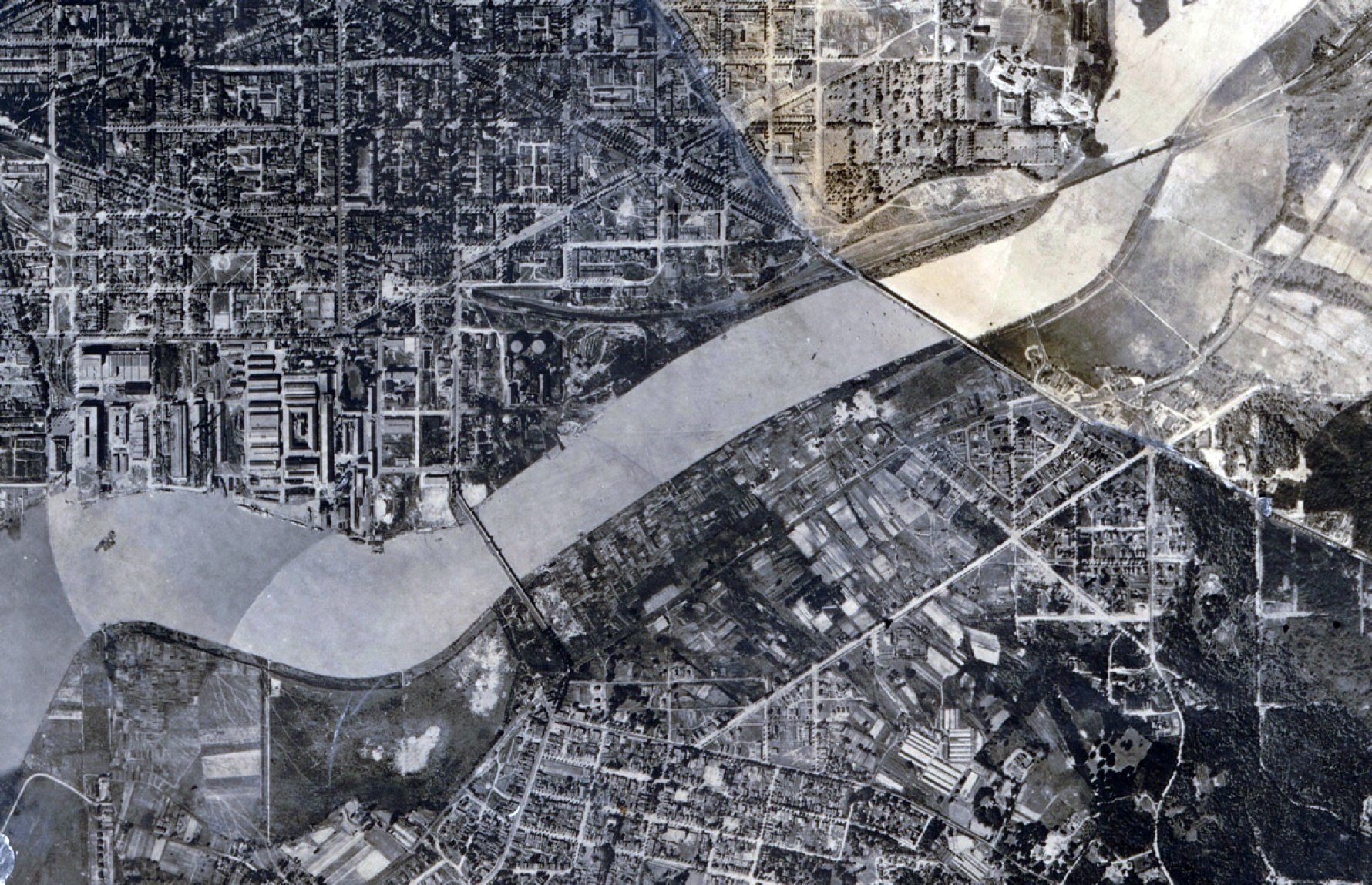
Excerpt from 1882 U.S. Coast & Geodetic Survey entitled “Washington and Georgetown harbors, District of Columbia.” Note the development of Barry Farm near Poplar Point, the Alexandria Branch of the Baltimore and Ohio Railroad, and the construction of the Baltimore and Potomac Railroad bridge (present-day CSX Railroad bridge) near Barney Circle. Note also the depths of the Anacostia flats at no more than 5½ feet. (Hildegard, J.E., et al., U.S. Coast & Geodetic Survey, Library of Congress)

The approximate boundaries of present-day Anacostia Park are overlaid in yellow on an 1884 U.S. Army Corps of Engineers map of the Anacostia River. Compare the existing shoreline in white with the present-day shoreline in yellow. Much of Anacostia Park had yet to be reclaimed as usable land. (Map excerpt from Louis Berger 2016: 52).

Proposed dredging and filling plan of the Anacostia River, developed by Lieutenant Colonel Peter C. Hains of the USACE. Annotations in red were drawn by the USACE in 1891 and indicate planned reclamation efforts south of the 11th Street SE bridge. Annotations in yellow are the approximate boundaries of the cultural landscape from the 2016 Louis Berger Archeological Assessment. While much of the cultural landscape would be created from reclaimed land, significant portions of it were also extant prior to dredging. (Hains 1891; Louis Berger 2016).

OPBG landscape architects Irving W. Payne and Thomas C Jeffers designed the first plans for Anacostia Park in Section D of the cultural landscape. Their design includes a central field house, Anacostia River Drive, an earthen amphitheater, various playing fields, a pool, and a grandstand. Note the southern portion of Section D, south of the field house and north of the railroad tracks had not yet been acquired for park purposes. (Payne and Jeffers 1924)

View of the Anacostia Field House, as built by 1931 and seen from the southwest, looking northeast. It was the first recreational building constructed in the cultural landscape. Construction began in 1925 and was completed by the time this photo was taken in 1931. Later alterations would change the appearance of the field house. (CHS 09985, General Photograph Collection, Historical Society of Washington, D.C.)
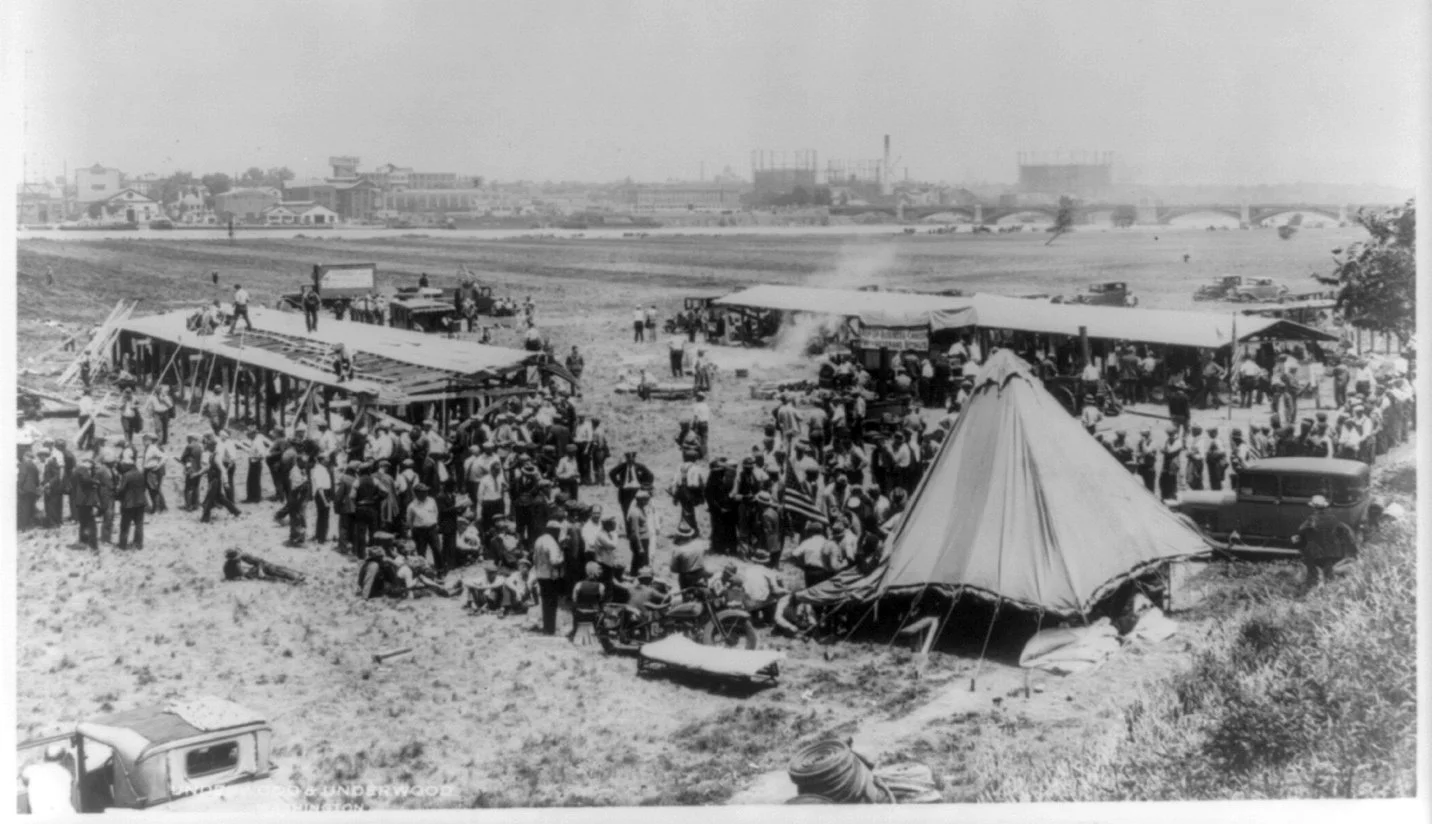
The earliest Bonus Army structures built in Section C of the cultural landscape were located on the southern end of the cultural landscape, adjacent to the existing tree nurseries and a small rise near the adjoining neighborhoods that residents used as a dump. The first structure, a bunkhouse located at the right side of the photo, was built with lumber and tar-paper provided by Police Chief Glassford. Using found materials, veterans continued to expand the camp. (Underwood and Underwood, Library of Congress Prints and Photographs Division, Washington, D.C., 1932a)

The Anacostia Pool, opened in 1937, was exclusively used by white patrons prior to 1949 (full desegregation of public pools in the District would not be final until 1954). (Evening Star, June 11, 1939: C5)

In 1949, Black youth attempted to gain access to the de-facto segregated Anacostia Pool and were met with racial violence. (D.C. Historic Preservation Office, “Civil Rights Tour: Recreation - Anacostia Pool, Swimming for All,” D.C. Historic Sites, accessed April 10, 2020, https://historicsites.dcpreservation.org/items/show/914)

View to the northeast from Section C with the 11th Street SE bridge at left. This 1964 photograph shows the significant changes made to the cultural landscape in Sections C and D caused by construction of the Anacostia Freeway. (Stewart Brothers, “Anacostia Freeway – 11th Street Interchange,” District Department of Transportation Historic Collections)