Fort DeRussy Park
Washington, DC | 2013 - 2014
Cultural Landscape Inventory
Project Team: Randall Mason, Shannon Garrison, Karina Bishop
History
Fort DeRussy was one of 68 forts built as a defensive ring around Washington at the start of the Civil War. Located on a high crest to the west of Rock Creek, DeRussy was sited to control movement across the valley below and coordinate fire with Fort Stevens to the east and Fort Kearny to the west. The fort, constructed by the 4th New York Heavy Artillery, was completed and garrisoned in fall of 1861. Fort DeRussy’s parapet measured approximately 208 yards and enclosed an area of 0.6 acres. In addition to the trapezoidal earthworks, an extensive rear-ditched rifle trench wrapped around the north face of the hill and connected to Battery Kingsbury, 380 yards southeast of the main fort, and Battery Smeade, located west of modern day Oregon Avenue. The 86-acre complex around Fort DeRussy included a rammed earth magazine and bombproof, both located within the fort. Two barracks, two mess halls, five officers’ quarters, two stables, an ordnance sergeant’s quarters and a guardhouse, all built of log or frame construction, were built outside the fortification.
The armament at Fort DeRussy included three 32-pounder seacoast guns en barbette, one 100-pounder Parrott en barbette, five 30-pounder Parrott rifles en embrasure, one 10-inch and one 24-pounder Coehorn mortar, and two vacant platforms. In 1863, the fort was expanded and the northeastern angle of the fort was reshaped to accommodate a 100-pounder Parrott rifle. The additional gun proved useful in providing long-range fire against Jubal Early’s raid on Fort Stevens on July 11-12, 1864. Fort DeRussy is one of only three of the Defenses of Washington to participate in direct action during the Civil War.
The fort reverted to civilian ownership at the end of the Civil War. Outbuildings were dismantled and timber, bricks, nails and hinges sold off at a public sale. The combined draw of the site’s historical association and the expansive views from its parapets led surveyors to recommend Fort DeRussy be preserved as parkland as early as 1867. In 1890, the fort was incorporated as part of the newly founded Rock Creek Park. The creation of the park was promoted as a remedy for urban ills. Large metropolitan parks such Rock Creek provided the fresh air, lakes, meadows and sunshine of the country, and were perceived as an antidote to the stress of indoor work and congestion of the city.
In early 1902, the publication of the McMillan Plan (written and developed in 1901) spurred efforts to preserve the Civil War Defenses as part of a circle of green spaces around the city. The original proposal, to create a 28-mile parkway connecting the Civil War forts of DC as a string of public parkland, was a part of the re-envisioning of the District of Columbia based on the principles of the City Beautiful Movement. Already preserved as a part of Rock Creek Park, Fort DeRussy was not included as one of the original chain of forts designed as part of the McMillan Plan, but was added to later revisions of the parkway plan.
Today, Fort DeRussy is situated above a busy road that bisects Rock Creek Park. Mature tree growth and heavy vegetation insulate the site from much of the street noise to the south. Since the mid-twentieth century, the National Park Service has maintained hiking, biking and horse trails around the fort. It is a popular spot among local dog walkers. While no evidence of outbuildings from the Civil War era is visible, the earthworks remain in a remarkable state of preservation. Though sections of the parapet have eroded and the magazines and bombproofs long ago collapsed, much of the fort and its outerworks retain their historic character.
Analysis + Evaluation
The Fort DeRussy Cultural Landscape Inventory finds that Fort DeRussy retains physical integrity from the Civil War-era period of significance (1861-1865) as well a second period of significance, (1890-1942) covering the foundation of Rock Creek Park, the development of the McMillan Plan and the transfer of the site’s management to the National Park Service. Fort DeRussy has retained many of its landscape characteristics and features from these periods, and displays all seven aspects that determine integrity as defined by the National Register of Historic Places: location, design, setting, feeling, materials, workmanship, and association.
Contributing landscape characteristics identified for Fort DeRussy are topography, spatial organization, land use, buildings and structures, circulation, vegetation, views and vistas, small-scale features and archeology.
Topography: Like all of the Civil War Defenses of Washington, the site for Fort DeRussy was selected for its topography. Its position over 400 feet above sea level provided an elevated vantage of the surrounding landscape, including strategic military sites such as Fort Stevens and Fort Kearny, that Fort DeRussy was designed to support and protect. The topography remains the same as it was throughout the historic period, and has a high degree of integrity.
Spatial Organization: The current spatial organization of the Fort DeRussy cultural landscape is similar to that of the first period of significance. At that time, the main earthworks were located at the topographic crest of the hill with a rifle pit to the north connecting the fort to Battery Kingsbury and Battery Smeade. Battery Kingsbury and the rifle pit were partially demolished and auxiliary buildings directly to the south of the fort were torn down after the war, but the landscape retains partial integrity of spatial organization. Battery Smeade, which was located west of modern day Oregon Avenue was located outside the boundaries established for this CLI. Though no research has been conducted to establish the exact date the Battery was demolished, its site is now a high school campus. It is unlikely that there are any extant remains of Battery Smeade or the rifle pits west of Oregon Avenue.
Land Use: The military’s use of Fort DeRussy ended when the government returned the property to its original owner in 1865. In 1890, the fort was incorporated as part of Rock Creek Park and remains public park land. As such, land use at Fort DeRussy retains a high degree of integrity to the second period of significance.
Buildings and Structures: The landscape has partial integrity of buildings and structures to the first period of significance. The earthworks, though deteriorated, are well preserved and remain extant as ruins. Rifle pits that connected Fort DeRussy with Battery Kingsbury and Battery Smeade are partially extant and some traces of Battery Kingsbury are visible. None of the Civil War-era buildings that were located directly south of the earthworks are extant.
Circulation: Fort DeRussy’s Civil War circulation pattern partially survives in the form of a path leading through the original sally port and the remains of rifle pits connecting the fort with Batteries Kingsbury and Smeade. The historic Milkhouse Ford Road, which forms the northern border of the site is also extant and has been incorporated into Rock Creek Park’s trail system. Military Road retains its original Civil War-era route south of Fort DeRussy, although it was expanded and modernized in the 20th century. Existing NPS trails partially trace original bridle paths and carriage roads constructed in the early 20th century. Partial integrity from the first and second periods of significance remains.
Vegetation: There was limited vegetation at Fort DeRussy during the Civil War, in keeping with the site’s strategic design and use. The current vegetation pattern is consistent with the later period of significance, when successive forest was allowed to grow. In the 1920s the site was replanted and some species were cleared, as recommended in the Olmstead Report of 1918. In recent years, invasive species have affected the early 20th century plan for the site and oak and tulip now appear to be the dominant species of tree, whereas cedar was noted as dominant in the area in 1918. Vegetation retains partial integrity from the second period of significance.
Views and Vistas: Fort DeRussy was sited to control movement in the Rock Creek Valley. The area/hillside around the fort was cleared in September of 1861 to afford a direct view of the valley, including Milkhouse Ford Road and Rock Creek. These views were impacted by replanting that occurred during the second period of significance. The continued growth of vegetation throughout the site has blocked original views completely. The present-day views retain no integrity to the first period of significance, and no significant views were designed during the second period of significance.
Small-Scale Features: The small-scale features at Fort DeRussy all post-date the second period of significance. Existing features include wayfinding, regulatory and interpretive signage. These features are consistent with the site’s land use as a public park during the second period of significance, and are therefore compatible but non-contributing.

1861 Boschke's map of Washington, DC showing future site of Fort DeRussy. The land owned by B. Swarts is not listed on this map (Library of Congress, Geography and Map Division)

1862 Topographic Map of Washington, DC showing land owned by Swarts. (Library of Congress, Geography and Map Division)

1866 Engineer Drawing of Fort DeRussy (National Archives, as printed in Mr. Lincoln's Forts)

Undated Civil War soldier's drawing of temporary camps around Fort DeRussy (National Archives, as printed in Mr. Lincoln's Forts)

Barnard's 1867 map of Civil War fortifications, showing relationship between Fort Kearney, Fort DeRussy, and Fort Stevens. (Library of Congress, Geography and Map Division)

1866 map of future site of Rock Creek Park, as surveyed by Major Nathaniel Michler, showing Fort DeRussy, Battery Smead and Battery Kingsbury. The area around all three earthworks was cleared of dense forest during the Civil War.

1982 photo of Fort DeRussy earthworks showing mature tree growth and leaf cover. (Vegetative Threats to Historic Sites and Structures 1983: 73)

1916 Survey of Rock Creek Park (Rock Creek Park Historic Trails Cultural Landscape Report)

1933 National Park Service Map of Trails (Rock Creek Park Historic Trails Cultural Landscape Report)

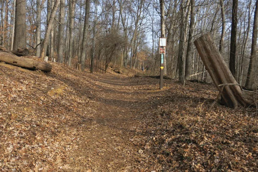
2014 photo for paved hiking path leading to Milkhouse Ford Road
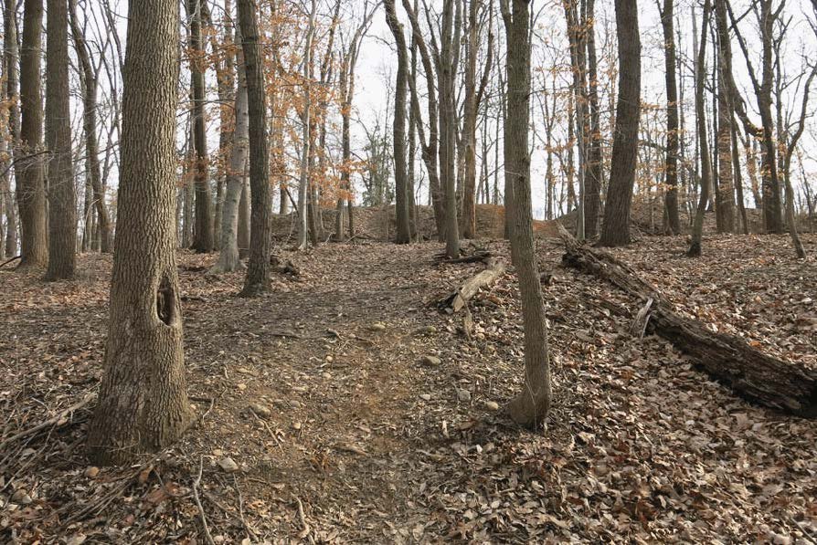
2014 photo of dirt hiking trail leading to Fort DeRussy earthworks

2013 photo showing mature tree growth along northern face of Fort DeRussy earthworks and in surrounding ditch
2013 trees on north face of Fort DeRussy

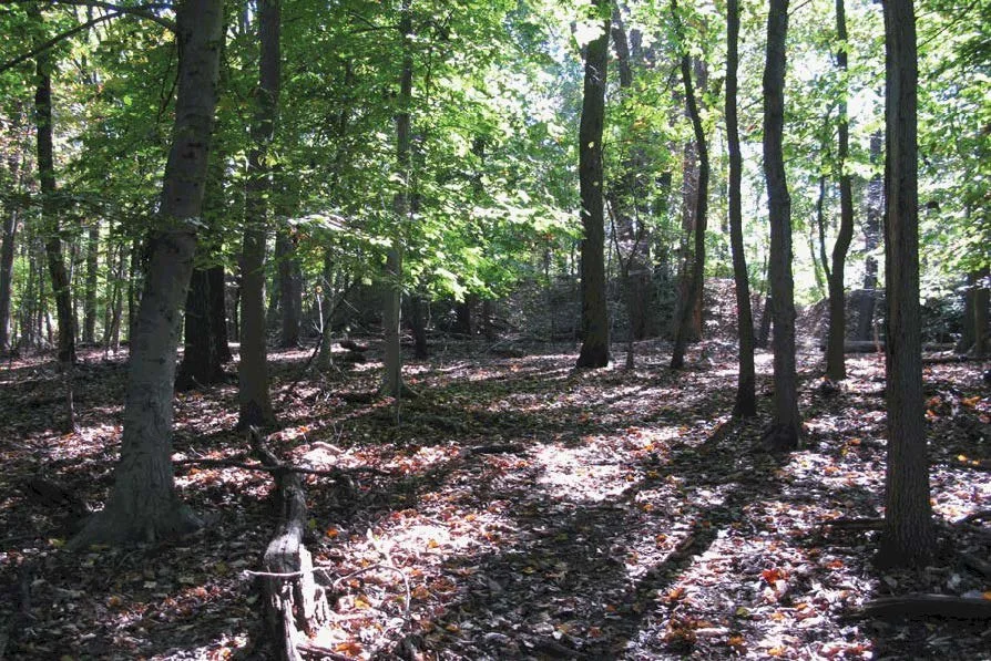
2014 successional forest of oak, beech, and tulip trees that have grown up around the fort since the end of the Civil War

2014 north face earthwork with social trail

2014 photo showing collapsed magazine with a social trail running through it
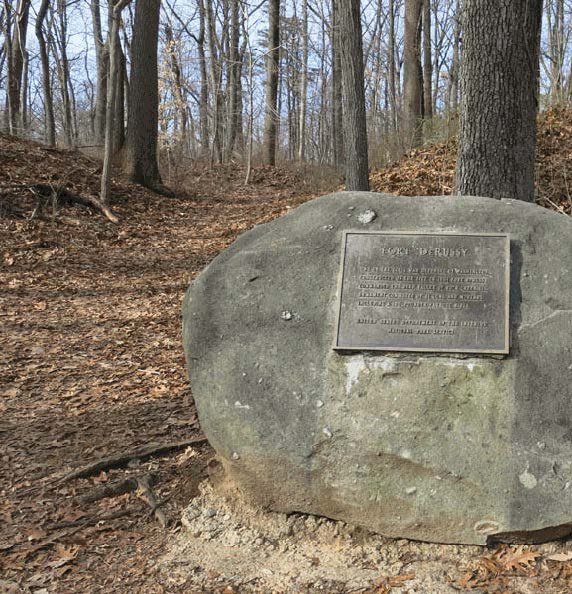
2014 photo of commemorative plaque and boulder placed at Fort DeRussy by the National Park Service

2014 interpretive signage near Oregon Avenue