Fort Drive
(Fort Slocum - Fort Totten segment)
Washington, DC | 2019 - 2020
Cultural Landscape Inventory + Rapid Ethnographic Assessment Protocol
Project Team: Randall Mason, Molly Lester, Jacob Torkelson, Sarah Lerner, Xue Fei Lin, Katherine Payne
History
The Fort Drive component cultural landscape was formally incorporated as part of the District of Colombia under surveyor Andrew Ellicott in 1792, although it wasn’t delineated or improved as a park until later periods. Until the mid-19th century, the cultural landscape remained primarily agricultural in use, with most parcels consisting of crops and forested areas. In 1763, William Dudley Digges patented ‘Chillum Castle Manor,’ which included 4,443 acres of land along the present-day boundary between the District of Columbia and Prince Georges County, Maryland. This included the cultural landscape, which after this time was used as a large-scale cash-crop plantation and was cultivated by enslaved laborers.
By the 1830s and 1840s, wealthy residents of Washington City began establishing ‘gentleman farms’ in the hills surrounding the city, due to the rapid urbanization in Washington City and a resultant desire to escape its unhealthful conditions. Suburbanization in the Antebellum period was spurred by the expansion of the Washington City street grid and the establishment of throughways such as the 7th Street turnpike. At the advent of the Civil War, the cultural landscape was divided among four substantial estates, farms, and plantations. By 1861, the cultural landscape included buildings, structures, roadways, and vegetation associated with the Caroline Fairfax Sanders plantation, ‘Woodburne.’
The period between 1861-1865 marked one of the most substantial periods of development for the cultural landscape, as Union forces rapidly constructed the Civil War Defenses of Washington in the hills surrounding the city. Existing forest, fields, structures, and other landscape features were indiscriminately cleared to make way for the construction of defensive features. Forts Slocum and Totten (constructed north and south of the cultural landscape) were connected through the cultural landscape by rifle trenches built by Union forces; there are no apparent physical traces within the study area dating to this era.
The post-bellum era saw rapid suburbanization in the northern portions of the District. Private developers used racial covenants to bar anyone of color from settling in these new developments, including those platted within the boundaries of the cultural landscape. By the time the 1902 McMillan Plan was published, the cultural landscape had been almost entirely subdivided and prepared for residential development. Among its design tenets, the McMillan Plan proposed a parkway connecting the former fortifications encircling Washington. In 1927, Congress passed enabling legislation to a create a parkway linking the Civil War-era fortifications and the rights-of-way between them.
The passage of the 1930 Capper-Cramton Act provided much-needed funds for the acquisition of the privately held lands for parkway purposes. However, even as the National Capital Park and Planning Commission (NCPPC) proceeded to acquire the cultural landscape, the agency lacked the Congressional authority to develop the land. As the cultural landscape awaited improvement as a parkway, the American Women’s Voluntary Services (AWVS) established a victory garden at the northern end of the cultural landscape in order to aid in the war effort during World War II. This garden has remained in continual use since World War II, and now operates as the Blair Road Community Garden. By 1968, thwarted by decades of failed large-scale proposals, the National Park Service (NPS) and NCPPC abandoned the idea of the Fort Drive as a parkway and shifted instead to preserving the land as an urban greenbelt. This was codified in the 1968 Fort Circle Parks Master Plan; the cultural landscape, however, saw little to no direct improvement under the plan. The last major change to the cultural landscape occurred in the 1970s, when the Mamie D. Lee School and Community Garden were built on the southern end of the cultural landscape.
Analysis + Evaluation
Landscape characteristics identified for the Fort Drive—Fort Slocum to Fort Totten Component cultural landscape are: land use; topography; spatial organization; circulation; views and vistas; vegetation; buildings and structures; and small-scale features.
Land Use: Land use refers to the principal activities conducted upon the landscape and how these uses organized, shaped, and formed the land. Historically, the Fort Drive component cultural landscape likely was used for agricultural cultivation associated with 17th- and 18th-century farms and plantations. The construction of the Civil War Defenses of Washington between 1861-1865 added a wartime defensive/military land use to the cultural landscape, which was abandoned post-conflict. Agricultural use continued into the late 19th and early 20th centuries, until wealthy suburbanites and real estate speculators acquired the cultural landscape and subdivided it into suburban lots (although few houses were ever built). The reservation’s use as open space for passive recreation was formalized during the first period of significance (1930-1968), when the cultural landscape was first acquired for improvement as the Fort Drive parkway. Changes made to the park during the second period of significance (1942-1945) maintained the park’s recreational use but added a renewed agricultural use with the creation of a victory garden within the study area. In 1968, the NPS identified Fort Drive (including the cultural landscape) as having exceptional natural, scenic, and environmental value, in addition to its recreational value. Around 1971, after the final period of significance, the study area’s agricultural use was expanded through the creation of the Mamie D. Lee Community Garden. The current uses of the cultural landscape are consistent with the final period of significance, and the Fort Drive—Fort Slocum to Fort Totten Component cultural landscape therefore retains integrity with respect to land use.
Topography: Topography refers to the three-dimensional configuration of the landscape surface, characterized by features such as slope, articulation, orientation, and elevation. The cultural landscape’s topography has remained relatively consistent through history, comprising natural rolling contours consistent with the landscape of northern Washington, D.C. These conditions were consistent through the first half of the 19th century, as development was slow to reach the rural countryside north of Washington City. The cultural landscape’s location in the hills overlooking the capital city made it an ideal site for inclusion in the Civil War Defenses of Washington. Union engineers used the natural curving ridgeline to the east and south of Fort Slocum to establish a series of rifle trenches that connected it to Fort Totten, through the cultural landscape; no traces of these trenches remain in the study area. The first significant changes to the study area’s topography are associated with late 19th- and early 20th-century suburbanization. when suburban railroads and street grids established the steeply-sloping human-made topography along many of the study area’s edges. Few other known changes were made to the topography of the cultural landscape after the 1930s, as several proposals failed to construct a formal Fort Drive. The current topography of the Fort Drive component cultural landscape is consistent with the conditions at the end of the periods of significance (1930-1968; 1942-1945), with no known significant alterations to the reservation’s grading or elevation since that time.
Spatial Organization: A cultural landscape’s spatial organization refers to the three-dimensional organization of physical forms and visual associations in the landscape, including articulation of ground, vertical, and overhead planes that define and create spaces. The cultural landscape was not formally organized into parkland until the 1930s. Prior to this time, it was organized as a series of privately-owned parcels associated with 17th-, 18th-, and 19th-century farms, plantations and estates. During the construction of the Civil War Defenses of Washington, the various future parcels of the cultural landscape were first linked by rifle trenches that connected Fort Slocum to Fort Totten within the larger system of defenses. The cultural landscape rapidly urbanized in the 20th century amid the construction of single-family houses and new residential streets that organized the cultural landscape into the growing street grid. By 1938, the National Capital Parks and Planning Commission purchased the majority of the cultural landscape, establishing the spatial organization as a series of separate segments of open space linking Fort Slocum Park to Fort Totten Park. By the end of the first period of significance (1930-1968), the cultural landscape was organized as five segments of parkland: 497a, 497b, 497c, 497d, and 451a. The spatial organization within the cultural landscape remained consistent during the second period of significance (1942- 1945), but was augmented when the American Women’s Voluntary Services (AWVS) established a community garden in Reservation 497b. This unified composition occupied the entire Reservation 497b and consisted of gridded plots consistent with the surrounding street grid. After the periods of significance (1930-1968; 1942- 1945), the NPS established the Mamie D. Lee Community Garden between 1971-1977 in Reservation 451a. This new community garden was organized much like its predecessor, the Blair Road Community Garden, and likely consisted of gridded plots. The spatial organization of the Fort Drive cultural landscape is consistent with the cultural landscape’s composition during the periods of significance. The site, therefore, retains integrity of spatial organization.
Circulation: Circulation is defined by the spaces, features, and applied material finishes that constitute systems of movement in a landscape. Circulation prior to the period of significance included the development of the suburban street grid, including unpaved streets through the cultural landscape. Most of these streets were either demolished or left to deteriorate after the cultural landscape’s acquisition during the period of significance; however, the cultural landscape retains traces of the former McCandless Place and Kennedy Streets within its boundaries. All of the small parks associated with Fort Drive, including the cultural landscape, are located within the city street grid that borders the parks on all sides. Internal circulation features are limited to those within the community gardens that link plots together. These are consistent and in keeping with the second period of significance (1942-1945). The existing conditions at the Fort Drive component cultural landscape are consistent with the circulation features in place by the end of the final period of significance (1930-1968). Additional features added after the period of significance, including those within the Mamie D. Lee Community garden and the Metropolitan Branch Trail and spur, are in keeping with the design of the cultural landscape during the periods of significance. The cultural landscape therefore retains integrity with respect to circulation.
Views and Vistas: Views and vistas are defined as the prospect afforded by a range of vision in the landscape, conferred by the composition of other landscape characteristics and associated features. Until the mid-19th century, the cultural landscape likely had limited views owing to the relatively undeveloped and forested nature of the rural countryside outside the city. Construction of Fort Slocum and Fort Totten during the Civil War (1861-1865) radically altered the views and vistas from the cultural landscape. Rapid clearing of the landscape during this time gave each fortification sweeping views of the surrounding countryside (Barnard 1871: 2; Lester 2017: 81; Boschke 1861). In the following decades, the cultural landscape continued to have panoramic views of the surrounding estates, plantations, and farms. These expansive views were largely a result of clear-cutting during the Civil War and were retained prior to the period of significance (1930-1968). However, by the end of the period of significance, vegetation had returned to the cultural landscape and mature trees covered Sections 497c and 497d. As a result, the views at the end of the period of significance were likely significantly different than the conditions when NCPPC acquired the cultural landscape, representing the evolution in conceptions of Fort Drive from parkway to urban greenbelt. Construction of the Blair Road Community Garden during the second period of significance (1942-1945) and the Mamie D. Lee Garden after the first period of significance (1930- 1968) marked a notable change to the viewsheds of the cultural landscape. The design of these gardens directed views along the unpaved informal paths between community garden plots. By the end of the first period of significance (1930-1968), the cultural landscape featured few views of surrounding landmarks, owing to the maturation of vegetation and adjacent urbanization. As a result, it features no significant views of external landmarks. The cultural landscape retains its internal views along the unpaved informal paths between community garden plots, consistent with the second period of significance (1942-1945). As a result, the Fort Drive component cultural landscape retains integrity of views and vistas.
Vegetation: Vegetation features are characterized by the deciduous and evergreen trees, shrubs, vines, ground covers and herbaceous plants, and plant communities, whether indigenous or introduced in the landscape. Prior to the Civil War, the cultural landscape consisted of agricultural fields, orchards, and forested areas. During the Civil War, the cultural landscape was largely cleared of vegetation, a condition that remained into the first few decades of the 20th century. Amid several failed development proposals during the periods of significance (1930-1968; 1942-1945) for a comprehensive Fort Drive, the cultural landscape slowly revegetated into majority-forested areas. During this time, the AWVS and NPS established the Blair Road Community Garden, which produced small-scale agricultural plantings. This use and vegetation pattern has remained in place since the second period of significance, and is extant today. By the end of the period of significance, much of the cultural landscape was majority-wooded areas, representing some of the largest natural areas in the city. No evidence was uncovered for this CLI to indicate that the cultural landscape featured any formal plantings or planting plans during the periods of significance. As such, conditions at the end of the periods of significance are generally consistent with today, and the cultural landscape retains integrity with respect to vegetation.
Buildings and Structures: Building features refer to the elements primarily built for sheltering any form of human activities; structures refer to the functional elements constructed for other purposes than sheltering human activity. Numerous buildings or structures existed in the Fort Drive component cultural landscape before the periods of significance (1930-1968; 1942-1945). The earliest known buildings or structures within the cultural landscape date to the Antebellum era and were associated with the estate of Caroline Sanders and William Rollins Sanders. According to the Boschke map, the plantation consisted of 11-12 buildings arranged along secondary or access roads that branched off of a main driveway. These conditions remained consistent through the Civil War, amid the construction of Forts Slocum and Totten outside the study area. During this time, rifle trenches were also constructed within the cultural landscape. Their design and locations are unknown and no apparent traces of them exist within the cultural landscape.
In the late 19th and early 20th centuries, residential buildings within suburban subdivisions overlooked the cultural landscape. Under the 1893 Highway Act, the L’Enfant Plan was extended into the greater Washington County. As a result, large estates that did not conform with the extended street grid were demolished, while others were absorbed into the growing system of streets and highways. Despite the rapid platting of the estates of Chillum Castle Manor (1891), Stott’s Park (1908), Chillum Castle Heights (1911), the cultural landscape remained largely unbuilt by the turn of the mid-20th century; as of 1925 the cultural landscape included only 2 residential structures. Between 1930-1968, the NCPPC acquired all private inholdings within the cultural landscape and demolished all extant structures, including the 2 pre-existing residential structures. The Blair Road Community Garden, built in 1942, was the first new structure built in the cultural landscape under the tenure of the NCPPC and NPS. The last structure added to the cultural landscape was the Mamie D. Lee Community Garden, built sometime between 1971-1977 (after the periods of significance), by the principal of the adjacent Mamie D. Lee School in conjunction with the NPS. The Mamie D. Lee Community Garden is a non-contributing feature of the cultural landscape, but is compatible with the historic agricultural use of the cultural landscape through the Blair Road Community Garden. The cultural landscape therefore retains integrity with respect to buildings and structures.
Small Scale Features: Small-scale features are the elements that provide detail and diversity, combined with function and aesthetics, to a landscape. Little is known about the cultural landscape’s small-scale features until the area’s late 19th century suburbanization. Small-scale features associated with real estate developments, such as streetlights, are the earliest known features within the cultural landscape. Few recorded small-scale features were added to the park since its acquisition by the NCPPC during the period of significance. The addition of the Blair Road Community Garden between 1942-1945 marked the most significant change in the cultural landscape’s smallscale features. The garden, during the second period of significance (1942-1945) likely included new fencing, irrigation, gates, compost bins, and other small-scale agricultural features. Most of these small-scale features have been continually repaired and replaced in-kind, in the decades since the periods of significance. The Mamie D. Lee Community Garden has featured similar small-scale features since its creation, which post-dates the periods of significance (1930-1968; 1942-1945). This addition marked the last major changes to the cultural landscape’s small-scale features. The presence of non-contributing features does not detract from the significant influence of the Blair Road Community Garden’s contributing features. The Fort Drive component cultural landscape therefore retains integrity of small-scale features.
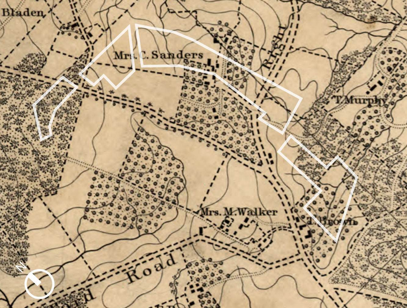
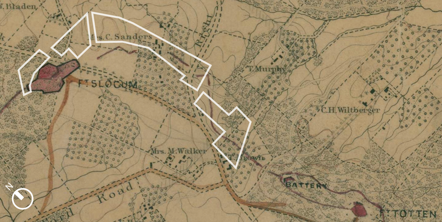
The approximate boundaries of the cultural landscape are shown in white. By 1861, the cultural landscape consisted of a patchwork of fields, orchards, wooded areas, plantations, and estates. Caroline Sanders, Tomas Murphy, Thomas Brown, and Mary Walker are among the known landowners prior to the Civil War. (Excerpt from Boscke 1861; annotated by the CLI author, 2020)

Photo of a gun at Fort Totten, looking northeast towards the vicinity of the cultural landscape. The vastly open landscape in the background is typical of conditions in the cultural landscape during and after the Civil War. (Excerpt from Smith 1865)
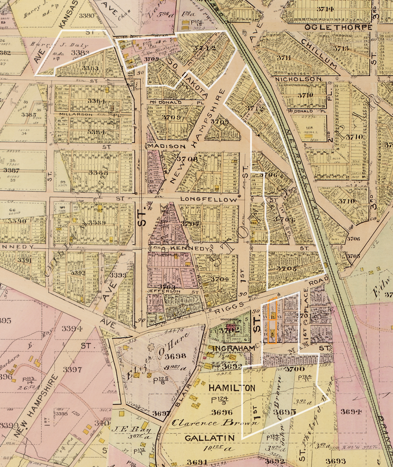
By the 1920s, nearly the entire cultural landscape (shown in white) had been subdivided for residential development. Former large estates and plantations were converted into developments such as Stott’s Park (yellow, right), Chillum Castle Manor (purple, bottom), and Chillum Castle Heights (yellow, left) However, only two houses were constructed within the cultural landscape. These were located in the Chillum Castle Manor section and are outlined in orange (Excerpt from Baist 1919-1921; annotated by CLI author, 2020).

This map, prepared by the D.C. Surveyor’s Office, shows the progress of land acquisition within the cultural landscape by 1933. Green parcels were those owned by the government. (Excerpt from “Map of the Permanent System of Highways,” 1933)

The 1965 Tuemmler report called for pedestrian overpasses linking the various segments of the cultural landscape at Kansas Avenue NW, Blair Road NW, New Hampshire Avenue NW, and Riggs Road NE. (Excerpt from Tuemmler 1965)

The service road in the Blair Road Community Garden (left) was formerly known as McCandless Place and is a remnant of the former street grid within the cultural landscape. Traces of the former Kennedy Street NE are located in Reservation 497c (Photos by CLI author, 2020).

Maturing vegetation and urbanization during the end of the period of significance (1930-1968) obscured any views of surrounding landmarks. (Left) Mamie D. Lee Community Garden looking northeast; (right) Reservation 497a looking west. (Photos by CLI author, 2020)

There is no documented history of trash cans or picnic tables during the periods of significance. However, one trash can and one picnic table were installed by the NPS sometime after 1968 in reservation 497a. View to the north. (Lester 2020).

Many of the edges of the cultural landscape feature steeply-sloping human-made topography where roads transect the various segments of the study area. View to the southwest of reservation 497a with Kansas Avenue NW at right (Photo by CLI author, 2020).
REAP Summary Observations
Our team spent a year studying the Fort Drive landscape between Fort Slocum and Fort Totten, building an understanding of both its history and its current value for the community that surrounds it. We conducted extensive archival research to understand the landscape as it took shape over several centuries, and we undertook a rapid ethnographic assessment to learn how that landscape is used and shaped by park visitors today. Based on this research, we offered some overarching observations:
This parkland does not feel like a park. Despite their geographic proximity, the segments of Reservations 497 and 451 are cut off from each other by busy roads and have no connective tissue to link them as public space in terms of identity, association, wayfinding, or experience.
This section of Fort Drive functions as No Man’s Land. These segments of parkland feel like leftover space: they are generally overgrown, and the heavily forested areas apparently discourage most use.
There are no physical remnants of the Civil War-era history that helped shape this landscape. Without any other associational or interpretive links with its eponymous forts (as a portion of Fort Drive), the parkland misses an opportunity to bear out its name and acknowledge how the current landscape came to be.
As the area around the parkland becomes wealthier, many existing gardeners are displaced. As gardeners are priced out of these neighborhoods, they move farther away from the gardens and must drive to the site. This introduces new conflicts of use and pressures for space with respect to parking.
The parkland remains an accessible public space in densifying, developing DC, but it offers little respite. The large-scale construction projects at Fort Totten Metro Station are a jarring neighbor to the parkland’s southern sections, as they generate noise, construction traffic, debris, etc. In that context, the Fort Drive parkland could offer respite from the development activity in the area. Yet, without features such as benches or walking trails, the park offers little opportunity for breathing room or rest from the surrounding hubbub.
Other than the two community gardens, there are very few features in the Fort Drive cultural landscape to encourage recreational use, and no features with historical associations or other clear cultural affiliations. There is only one picnic table in Reservations 497/451a. The remaining parkland is generally forested, with few trails and no features to encourage activity as recreational public space. The Blair Road Community Garden is linked with a historic World War II-era Victory Garden in the same location, but its legacy and historic significance is known by only a few long-time gardeners.
The community gardens are physically and functionally distinct from the parkland around them, and operate independent of any Fort Drive identity. Each of the two community gardens has its own identity and stakeholders, but the gardens are not integrated in any way with the parkland around them.
The community gardens have loyal followings, but these groups are associated with the gardens, not the parkland that hosts the gardens. We interviewed and surveyed the community gardeners at Blair Road and Mamie D. Lee Gardens, but there was a clear distinction in their responses between their observations about the gardens (they had many thoughts) and the parkland around the gardens (to which they have given little thought). The parkland was generally irrelevant to their use and experience of the gardens.
The gardeners are generally aware of the National Park Service’s ownership and management presence, but they are consequently also more aware of any conflicts with NPS stewardship. The community gardeners demonstrated awareness of NPS’ role in this landscape—more so than at the other cultural landscapes where we’ve conducted REAPs—this could instill a deeper appreciation for the National Park Service’s importance as a steward of public parkland. However, it also means that the gardeners are more aware of any perceived issues with respect to deferred maintenance, challenges in securing permits, etc.
The park has few identifiable stakeholders beyond the gardeners. We uncovered very few distinct stakeholders or organizations that use this parkland. This has implications for the stewardship of this public space.