Fort Foote Park
Fort Washington, Maryland | 2013 - 2014
Cultural Landscape Inventory
Project Team: Randall Mason, Shannon Garrison, Karina Bishop

History
Fort Foote was one of the 68 forts built as a defensive ring around Washington during the Civil War. It represented the distillation of two years of knowledge and practical experience building forts in the defense of Washington. Positioned on a commanding bluff 100 feet above the Potomac River, Fort Foote was armed with four 200-pounder Parrott rifles (en barbette) six 30-pounder Parrott rifles (en embrasure) and two 15-inch Rodman guns. Thus armed, the fort controlled the river for a distance of three miles below its location. The finished fort had a perimeter of 472 yards and a river-facing front 515 ½ feet long with a return of 75 feet at an angle of 120 degrees. These two faces, which constituted the water battery, were armed with heavy artillery—four mounted Parrotts and the two giant Rodmans. The rear of the fort, running parallel to the long water-facing side, was armed with field and siege guns for land defense. Fort Foote was the only Civil War fortification of Washington, DC to be built as a permanent defense and remained in active service until 1878.
Post Civil War, the fortification underwent extensive regular modifications, including the addition of concrete magazines and reinforcement of much of the fort. Many of the outbuildings, and the fort’s wharf, had been hastily built between 1863 and 1864, and were badly in need of repair. Nearly all of the original buildings were rebuilt between 1865 and1876. By the time the army decommissioned the fort, in 1878, over 20 buildings and structures including two officers’ quarters, a hospital, barracks and laundresses’ quarters, were located on site. These buildings were left to deteriorate, though some were reused in 1902 when Fort Foote was reactivated as an occasional practice area for students from the Army’s Engineer School. According to material published by the Army Corps of Engineers in 2005, engineer troops were stationed at Fort Foote during World War I, where they carried out gas service testing.
Though the site was not officially converted to parkland until 1930, local scout troops used Fort Foote for weekend camping trips as early as 1914, and the community began pressuring the US Army to turn over the site for use as a public park in the early decades of the 20th century. In 1902, the publication of the McMillan Plan spurred efforts to preserve the Civil War Defenses as part of a circle of green spaces around the city. The original proposal to create a 28-mile parkway connecting the Civil War forts was a part of the City Beautiful movement’s re-envisioning of the District of Columbia. Located outside the boundaries of the DC, Fort Foote was never included in the chain of forts, but later versions of the McMillan plan would include the site as a part of a planned extension of the George Washington Parkway, a scenic drive leading from Mount Vernon to the capital.
Though the planned expansion of the George Washington Parkway to Fort Foote was never realized, the movement to convert the military site to a park for recreational use by the local community is an expression of city planning principles promoted by the City Beautiful Movement. It is also an early, albeit small, example of the movement to preserve military sites for public use as national parks.
Today, Fort Foote is situated in a suburban community facing rapid redevelopment pressure, in the form large-scale projects such as the National Harbor complex. This multi-use development, located approximately 1.5 miles from Fort Foote, includes a convention center, six hotels, restaurants, shops and condominiums. As of 2014, an MGM Grand casino was planned to open at the site. Despite ongoing development north of the site, heavy vegetation surrounding Fort Foote gives the place an isolated feel. The park is surrounded by single family homes and popular with dog walkers and visitors interested in the Rodman guns, which were remounted in their original location in 1984. Locals use the old wharf road to access the Potomac and occasionally fish near the site of the wharf. A few brick outbuildings, such as the engineer’s storehouse, the ice house and a capped well—all dating to the second period of significance—are extant. Although erosion has affected sections of the fort itself, and concrete magazines and bombproofs have collapsed, the earthworks remain in a remarkable state of preservation and retain their historic character.
Analysis + Evaluation
The Fort Foote Cultural Landscape Inventory finds that Fort Foote retains integrity from the Civil War-era period of significance (1861-1865), a second period of significance (1865-78), during which the fort remained in active military service, and a third period of significance (1902-1934), dating to its use for recreational purposes by the local community, its reactivation as a World War I training site, and its eventual conversion to a public park under the management of the National Park Service. The Fort Foote cultural landscape displays all seven aspects that determine integrity, as defined by the National Register of Historic Places. The seven aspects of integrity are: location, design, setting, feeling, materials, workmanship, and association through the retention of landscape characteristics and features.
Contributing landscape characteristics identified for Fort Foote are topography, spatial organization, land use, buildings and structures, circulation, vegetation, views and vistas, small-scale features and archeology.
Topography: The site for Fort Foote was selected for its topography and position along the Potomac River. Located on a bluff 100 feet above the river, Fort Foote provided an elevated vantage of the surrounding landscape, most notably the river approach to Washington, DC, which Foote was designed to protect. The topography remains the same as it was during the first period of significance, and has a high degree of integrity.
Spatial Organization: The current spatial organization of the Fort Foote cultural landscape is similar to that of the first period of significance. At that time, the main earthworks were located at the topographic crest of the bluff overlooking the Potomac River, with a road leading from the sally port down to the river and a trail running along the parade ground. The majority of the auxiliary buildings, located north of the fort, were torn down in the early twentieth century. The landscape retains partial integrity of spatial organization.
Land Use: The military land use aspect of Fort Foote officially ended in 1878, when the site was decommissioned. The US Government retained the land until 1930 when it was transferred to the office of Public Buildings and Public Parks of the National Capital, for inclusion as part of a planned extension of the George Washington National Memorial Parkway. Though the designed extension was never realized, the site has been open as a public park since 1931. Prior to its official opening as a park, the site was used for recreational purposes by local girl and boy scout troops. Land use at Fort Foote retains no integrity from either of the 19th Century periods of significance. It retains a high degree of integrity to the third period of significance.
Buildings and Structures: The Fort Foote landscape has partial integrity of buildings and structures. The earthworks, though deteriorated, remain extant as ruins. Concrete magazines and bombproofs are collapsed but still present onsite. Two extant buildings—an engineer’s storehouse and an ice house—and one structure—a capped well—date from the second period of significance. The foundations from many 19th century buildings are present throughout the site . The mounted Rodman guns and five gun platforms are original to Fort Foote’s first period of significance. The gun carriages are full to partial reconstructions, dating to 1984 when the canons were remounted.
Circulation: Fort Foote’s Civil War circulation pattern partially survives and retains integrity from the first and second periods of significance. The original wharf road leading from the dock to the fort is deteriorated, but survives in the form of a rough trail. The parade grounds are extant and the original path leading from the northern edge of the grounds, along the bluff, past the cemetery to the river partially exists. More research is needed to determine whether the new trail leading from the parade ground to the northern edge of the site dates to the third period of significance but it partially traces the original 19th century path. Footpaths through the sallyport and around the earthworks survive, as do limited footpaths through the magazines and bombproofs.
Vegetation: Vegetation at Fort Foote retains partial integrity from the first and second periods of significance. Brush and trees were cleared directly surrounding the fort to allow for sightlines from the guns to the Potomac and along the landward side. Vegetation was also cleared for the building of auxiliary structures, the parade ground and cemetery and for the garden. Much of this area remains clear of vegetation, particularly the parade ground. The garden is now covered with meadow-like vegetation and trees and brush have grown up over the earthworks and sites of the barracks, hospital and other structures during the past 125 years.
Views and Vistas: Fort Foote was sited to control movement along the Potomac, and the bluff below the fort was cleared of vegetation during the first period of significance, to afford direct views of the river. These views have been impacted by regrowth along the bluff since the site was abandoned by the military in 1878. Beginning in the 1980s, and as recently as 2000, the National Park Service has attempted partial clearance of vegetation to restore original views in front of the Rodman guns, but vegetation obstructs nearly all of the original views for much of the year. Original views along the parade ground remain partially extant, especially from the former site of the officer’s quarters. Fort Foote retains partial integrity of views from the first and second periods of significance.
Small-Scale Features: The small-scale features at Fort Foote all post-date the three periods of significance. Existing features include wayfinding, regulatory and interpretive signage and are outside the periods of significance. Fort Foote retains no integrity of small-scale features to the first two periods of significance.

1861 Martenet map of Prince George’s County showing location of Rozier’s Bluff and the future site of Fort Foote. (Library of Congress, Geography and Map Division)

1865 Engineer Drawing of Fort Foote (National Archive, as printed in Mr. Lincoln’s Forts)
![Undated photograph of Fort Foote [possibly 19th century] (National Park Service
Museum Resources Center)](https://images.squarespace-cdn.com/content/v1/6140e3c6390abd159b410cb8/2e904b7d-8e17-421b-8bee-e526fd630cca/Fort+Foote_Page_036_Image_0001.jpg)
Undated photograph of Fort Foote [possibly 19th century] (National Park Service Museum Resources Center)

1872 Map of Fort Foote showing post Civil War buildings and structures, circulation patterns and land use. (National Archives Geography and Map Division)

1872 Drawing of guardhouse at Fort Foote. (National Archives Geography and Map Division)

Undated photograph of scouting troop at Fort Foote, in front of Rodman cannon. Probably early 20th century. (National Capital Parks- East)

1872 Map of Fort Foote showing spatial organization and circulation patterns dating to the first and second periods of significance.
The parade ground. Much of the daily activity at Fort Foote took place around the parade ground during the first and second periods of significance (2014 CLP/NCR).

Fort Foote’s sally port which remains the main entrance to the fort (2014 CLP/NCR).

Mature tree growth on magazines and bombproofs to the left and parapets to the right (2014 CLP/NCR)

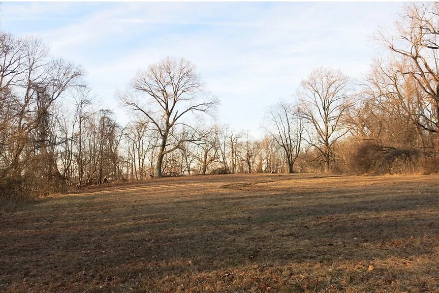
Meadow landscape on the former site of the Fort Foote garden (2014 CLP/NCR).

Ground cover and growth covering concrete magazine (2014 CLP/NCR).

South façade of Engineer’s Storehouse showing recent graffiti.
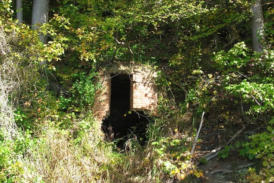
Icehouse, located on the bluff south of the former wharf site (2014 CLP/NCR).

North Rodman canon, remounted in 1984.

Empty gun emplacements (2014 CLP/NCR).

Station and gravel road leading to F.A.A. transmitter (2014 CLP/NCR).

View from north Rodman canon