Fort Marcy Park
McLean, VA | 2014 - 2015
Cultural Landscape Inventory
Project Team: Randall Mason, Shannon Garrison, Collette Kinane

History
Fort Marcy was one of 68 forts built as a defensive ring around Washington at the start of the Civil War. Located in the Arlington Heights, the fort was constructed in September of 1861. Unlike the majority of the defenses of Washington, Fort Marcy was not built to protect the city itself, but rather to control movement across the Leesburg Turnpike and Chain Bridge. The Chain Bridge was a key crossing over the Potomac River and one of the major approaches to Washington. DC. Fort Marcy, along with Fort Ethan Allen, was considered of vital importance in securing the Union Army’s continued presence in northern Virginia. Fort Marcy’s irregularly shaped parapet measured approximately 345 yards and enclosed and area of about 1.5 acres. The fort had emplacements for eighteen guns. Armament consisted of three 24-pounders en barbette, two 12-pounder howitzers, six 30-pounder Parrott rifles, three 20-pounder Parrott rifles, three 10-pounder Parrot rifles, one ten-inch mortar and two or three 24-pounder Coehorn mortars.
In addition to the main earthworks, rifle trenches were dug in a nearly continuous line to the Potomac River, above and below the Chain Bridge. Eight unarmed batteries were constructed at different points along the line to protect the valley of Pimmit Run and other areas unseen by Forts Marcy and Ethan Allen. Outworks extended north from Fort Marcy to anchor the fortification to the river. The line also ran south and west of the fort, across Pimmit Run to Fort Ethan Allen. An eight-gun battery was located directly west of the main fort, and two one-gun batteries south of Fort Marcy protected the Pimmit Run valley from either side of the creek. An extensive system of military roads, constructed by the Union Army, connected the main fort with surrounding batteries and Fort Ethan Allen.
The fort reverted to civilian ownership at the end of the Civil War. The Vanderwerken family retained ownership of the fort and surrounding land for the next 88-years, leaving Fort Marcy untouched. In 1953 the fort was sold to Ann DeLashmutt. In the 1950s, the combined threats of new ownership and road expansion led local activists to advocate for the federal government to purchase the fort as part of the George Washington Memorial Parkway’s northern extension, and preserve the site as a public park. In 1959 the National Capital Planning Committee acquired the land and in 1963 it opened to the public. At least one Civil War-era cannon was installed at the site as part of the celebrations surrounding the opening of the new park, and vegetation was cleared to provide areas for picnicking, and aid in interpretation of the site.
Today Fort Marcy is among the best preserved of the Civil War Defenses of Washington. Though a section of the parapet was bulldozed, and natural and visitor related erosion has affected the site, the earthworks remain in a remarkably good state. Mature tree growth and heavy vegetation insulate the fort from the heavy traffic on the GWMP. Residential development in the area immediately surrounding the fort has increased since the 1960s, and large suburban houses now surround the park. Local homeowners are probably the most regular visitors to the site, using Fort Marcy and its surrounding trails for walking dogs and jogging.
Analysis + Evaluation
After evaluation of the landscape features and characteristics within the context of the seven aspects of integrity established by the National Register, the Fort Marcy Cultural Landscape Inventory found that Fort Marcy remains extant and retains high integrity to both the 1861-1865 and 1953-1963 periods of significance. While the Civil War-era landscape has been impacted by the loss of some features, as well as natural deterioration of the site, the fort remains in a remarkable state of preservation. The park has been altered only slightly since the later period of significance, when it was opened to the public for recreational purposes.
Contributing landscape characteristics identified for Fort Marcy are topography, spatial organization, land use, buildings and structures, circulation, vegetation, views and vistas, small-scale features and archeology.
Topography: Like all the Civil War Defenses of Washington, the site for Fort Marcy was selected for its topography. Its position on a steep hill in the Arlington Heights provided an elevated vantage of the surrounding landscape, and direct sight lines to the Georgetown-Leesburg Turnpike and the Chain Bridge. Control of the turnpike and Chain Bridge were of vital importance to the Union’s defensive strategy in the protection of Washington. The topography of Fort Marcy remains the same as it was throughout the historic period, and has a high degree of integrity.
Spatial Organization: The current spatial organization of the Fort Marcy cultural landscape is similar to that of the first period of significance and relatively unchanged since the second period. During the first period of significance the main earthworks were located at the topographic crest of a hill overlooking the Chain Bridge. Outworks connected Fort Marcy with the Potomac River to the northeast and Pimmet Run to the south. Surrounding batteries provided support, including one directly west of the fort and two south of the fort. These batteries are partially extent and within the project area. The layout of the fort, and its surrounding batteries and outworks, is largely unaltered since the Civil War, and illustrates many of the original design principles used in the fort’s construction. It retains partial integrity to the first period of significance. The partial destruction of the fort’s southeastern parapet reoriented the entrance to the fort away from the original sally port, providing access from the newly built parking lot to the south. Construction of the George Washington Memorial Parkway (GWMP) also cut through some outworks between Fort Marcy and Fort Ethan Allen. The section of the GWMP that runs through the project area, and an offramp/onramp, were constructed during this time to provide access to the newly opened park. The spatial organization of Fort Marcy remains consistent with the 1960s design for the park, and retains a high level of integrity to the second period of significance.
Land Use: The military land use of Fort Marcy ended when the government returned the property to its original owner in 1865. It has no integrity of land use from that period. However, the land use of the project area has not changed since the second period of significance, when it was opened as a public park in 1963. The site is an attraction for tourists and locals who are interested in its recreational and historic value. Land use at Fort Marcy retains a high degree of integrity to the second period of significance.
Buildings and Structures: The Fort Marcy Cultural Landscape has partial integrity of buildings and structures from the first period of significance. The earthworks, though deteriorated, remain extant as ruins. Outworks and batteries to the west and south are clearly visible, though deteriorated. None of the Civil War-era buildings are extant. Additions to the site during the second period of significance include historic stone masonry guard walls and a bridge crossing Pimmit Run. These additions are considered contributing as part of the original design for the GWMP. Fort Marcy’s buildings and structures retain integrity to the first and second periods of significance.
Circulation: Fort Marcy’s Civil War circulation pattern partially survives in the form of a path leading through the original sally port and the remains of outworks and military roads that originally connected the fort with the Potomac River and batteries to the south. Circulation patterns through the project boundaries via the GWMP are consistent with those present during the second period of significance. The site retains partial integrity from the first period of significance and high integrity from the second.
Vegetation: There was limited vegetation at Fort Marcy during the Civil War, in keeping with the site’s strategic design and use. The current vegetation pattern is consistent with the later period of significance when trees and bush were cleared from the fort before it opened as a park and some landscaping was designed around the turnoff from the GWMP. In recent years trees and brush have grown in, covering parts of the site that were cleared in the 1960s. Vegetation retains no integrity from the first period of significance and partial integrity from the second period of significance.
Views and Vistas: Fort Marcy was sited to control movement over the Chain Bridge, thus an unobstructed view of the bridge, and the approach to it from the Leesburg Turnpike, was of primary importance during the Civil War. The area immediately surrounding the fort was cleared of trees in September of 1861 to afford views in all directions from Fort Marcy. These views were impacted by natural re-growth at the site over the nearly hundred years between periods of significance. No significant views were designed during the second period of significance and the present day site has no integrity of views from the first period of significance.
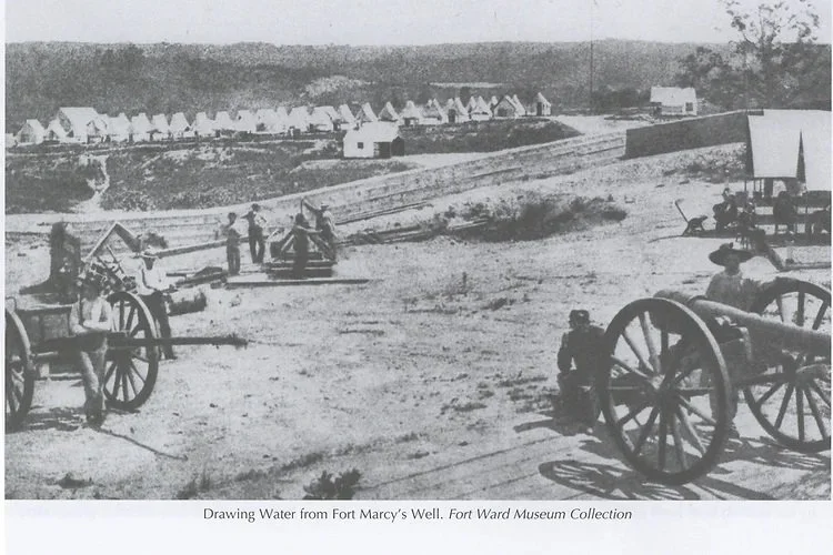
Small Scale Features: Except for a capped well located within the fort, the small-scale features at Fort Marcy all post-date the first period of significance. More research is needed to determine which, if any of the existing wayfinding and interpretive signage dates to the second period of significance. All are considered compatible. Two civil war-era howitzer cannons are installed at Fort Marcy. One of the cannons was installed in 1963. Installation of the second cannon is probably outside the periods of significance but it is considered compatible. Neither cannon was used at the fort during the Civil War but serve interpretive functions. Fort Marcy retains little integrity of small-scale features to the first period of significance and partial integrity to the second period.
Archeology: Multiple archeological investigations have been conducted at Fort Marcy over the past two decades. Finds at the site indicate the fort contains a rich store of knowledge from the Civil War era, and may provide information about Native American settlements, early Colonists and their descendants.

“Washington, D.C. Chain Bridge Over the Potomac; Chesapeake and Ohio Canal in Foreground,” William Morris Smith, 1865. Library of Congress Prints and Photographs Division. Accessed: http://hdl.loc.gov/loc.pnp/cwpb.04112

Map showing Fort Marcy in relation to Forts Sumner and Ethan Allen and support batteries and outworks, all show in pink, from “Map of the environs of Washington: compiled from Boschke's map of the District of Columbia and from surveys of the U.S. Coast Survey"

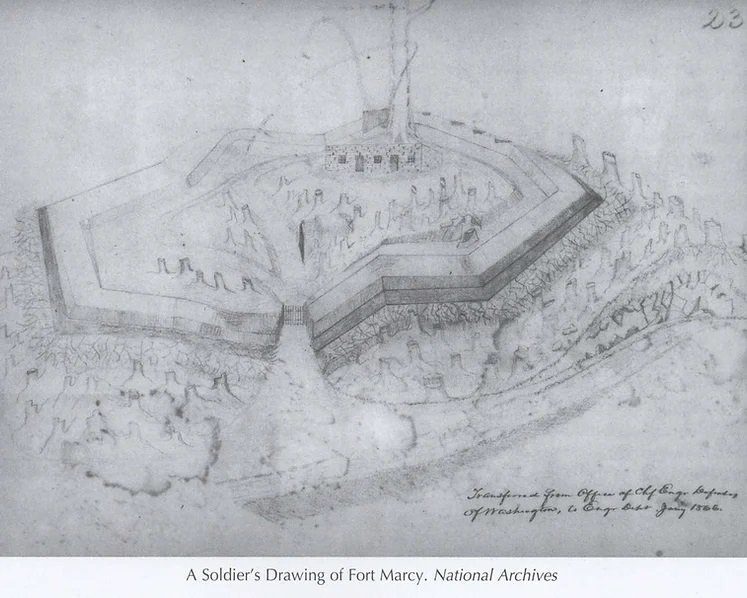
Barnard’s engineering drawing of Fort Marcy showing plan and sections. Image from Mr. Lincoln’s Forts, Benjamin Franklin Cooling and Wallace Owen, 2010.

Photograph of Fort Marcy. Image from Mr. Lincoln’s Forts, Benjamin Franklin Cooling and Wallace Owen, 2010.

Plan for Fort Marcy showing buildings. Image from Mr. Lincoln’s Forts, Benjamin Franklin Cooling and Wallace Owen, 2010.
Photograph of Fort Marcy. Image from Mr. Lincoln’s Forts, Benjamin Franklin Cooling and Wallace Owen, 2010.
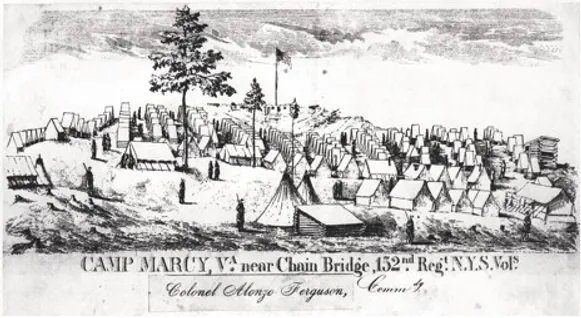
An undated lithograph showing a view of Fort Marcy from the soldiers camp.

Site plan for Fort Marcy park, showing access road, parking lot and clearance areas. 1960, National Park Service, George Washington Memorial Parkway.

Support Battery, photo taken by author in December 2014

Main Fort, photo taken by author, December 2014

Main Fort, showing portion demolished at unknown date, photo taken by author, December 2014.

Main Fort, showing social trail over embrasure, photo taken by author, December 2014.
Drawing of Fort Marcy. Image from Mr. Lincoln’s Forts, Benjamin Franklin Cooling and Wallace Owen, 2010.

Main Fort, erosion of parapet, photo taken by author, December 2014.

Canon at Fort Marcy, photo taken by author, December 2014.

NPS signs at Fort Marcy, photo taken by author, December 2014.

NPS sign at Fort Marcy, photo taken by author, December 2014