Grant Circle
Washington, DC | 2016 - 2017
Cultural Landscape Inventory
Project Team: Randall Mason, Shannon Garrison, Joseph Mester
History
Grant Circle, named after Ulysses S. Grant, is located in the heart of the Petworth neighborhood, in northern Washington, DC. Petworth was the first suburb in the District to conform to the pattern of the L’Enfant Plan for the City of Washington. In accordance with an 1888 law mandating that new streets and avenues in the city be laid out in alignment with those of the historic core, Petworh developers hired DC surveyor, William Forsyth, to plan the neighborhood based on L’Enfant’s pattern of broad avenues, streets and circles.
Despite its design and subdivision in 1889, Petworth’s development stalled during the 1890s. Streets were unpaved until the early 1910s, when houses finally began to populate the parcels around Grant Circle. In 1916 Commissioners of the District of Columbia made several recommendations for improving the neighborhood, including grading Grant Circle, laying a concrete sidewalk around its perimeter and paving the traffic rotary surrounding it. Between 1920- and 1924, Irving W. Payne, architect for the Office of Public Buildings and Grounds of the National Capital, produced a plan for landscaping the circle and its surrounding triangle parks. Construction and planting was completed between 1925 and 1928.
Upon its completion in the 1930s, the Petworth neighborhood became the only area in Washington, D.C. where the 18th century design for the capital was faithfully extended outside the city’s original boundaries. Grant Circle was the major impetus for development in the area, and it remains an important feature in the neighborhood.
Analysis + Evaluation
The Grant Circle Cultural Landscape retains integrity from both periods of significance: the period of its initial platting (1889) and the period during which it was finally designed and built (1916-1928). Grant Circle has original landscape characteristics and features and displays many of the seven aspects that determine integrity as defined by the National Register of Historic Places, including: location, design, setting, materials, feeling and association.
Contributing landscape characteristics identified for the Grant Circle cultural landscape are land use, topography, circulation, vegetation, small-scale features, spatial organization and views and vistas.
Land Use: During the first period of significance Grant Circle was platted and its land set aside for use as a public park. The circle and its associated reservations were designed and built during the second period of significance. Since that time the site has functioned as urban parkland, and retains integrity to the first and second periods of significance.
Topography: Grant Circle was graded, filled and leveled during its initial phase of development, between 1916 and 1926. The site’s flat terrain was part the platting plan for the Petworth development and has been maintained to the present day. Its topography retains integrity to the first and second periods of significance.
Circulation: Irving Payne’s 1921 and 1924 designs for Grant Circle established a system of radiating concrete walkways as the site’s organizing circulation pattern. A 10-foot wide circular sidewalk was installed along the edge of the park. A larger, 15-foot wide circular walkway ringed the site’s central focal point, an approx. 110-foot diameter circle, planted with a large Himalayan Cedar. Twelve lateral crossways ran between the two circular walkways, extending out to the Grant Circle traffic rotary. The walkways measured 8-feet across and were situated inline with the edges of New Hampshire and Illinois Avenues and Varnum Street. The entire arrangement resembled a wheeled spoke and created twelve grass panels that were planted with turf, trees and shrubs. The circulation pattern at Grant Circle remained unchanged until the 1990s when the entire site was excavated in order to install a DC Metro substation underneath the park. In 1997 the site was fully restored according to Payne’s 1924 plan, and the original circulation pattern, established during the second period of significance, was reinstalled. The historic circu and ation design for Reservation 312A has likewise been maintained and remains present today. The circulation patterns at Grant Circle and Reservation 312A retain a high degree of integrity to the second period of significance. No formal circulation pattern was designed for Reservation 312I during either period of significance, though a perimeter sidewalk was installed during the second period of significance. The current circulation dates to the 1997 rehabilitation of the landscape by DC Metro and does not retain integrity to either period of significance.
Vegetation: The majority of the vegetation at Grant Circle, originally planted between 1926 and 1928, seems to have survived through the late 1980s. Original trees consisted mainly of ginkgo trees (Ginkgo bilobas) American elms (Ulmas americana) and various evergreens, including a large Himalayan cedar (Cedrus deodora), planted in the center of the circle. Between 1988 and 1990 a rehabilitation plan called for the replacement of many of the original gingkos and elms. These were replaced in kind. In 1994 the construction of a power substation underneath Grant Circle required the removal of all vegetation, with the exception of the Himalayan cedar and three other pines. The circle was restored in 1997, and new plantings installed, according to Irving Payne’s 1924 plan. All vegetation was replaced in kind, with the exception of the Himalayan Cedar and three original pines, which survived the excavation. As these four trees are the only vegetation remaining from the second period of significance, the sites retains partial integrity of vegetation.
Small-Scale Features: Nearly all small-scale features of the Grant Circle cultural landscape post-date the period of significance. The only historic small scale features at the site are a cast-concrete pedestal-style drinking fountain, perimeter curbing and three small stairways at Reservation 312A The present curbing at Grant Circle is all replica; it was reinstalled in 1997 after Metro’s excavation of the site. All other small-scale features currently in place throughout the cultural landscape are modern additions with no historic significance to the cultural landscape. The site’s small-scale features retain partial integrity to the second period of significance.
Spatial Organization: The current spatial organization of the Grant Circle cultural landscape is nearly identical to that envisioned by Irving Payne during the second period of significance. The primary organizing elements from this period are bilateral symmetry, circular geometry and straight-line axes. These elements were expressed through walkways and plantings and are still in effect today. Reservation 312A was organized with a similar focus on geometry and symmetry, a focus which has been maintained since its initial planning in 1920. The current spatial organization at Reservation 312I dates to the 1997 restoration of Grant Circle following Metro’s excavation of the site. Prior to 1997 the site was simply organized as a triangle park with perimeter sidewalk. Despite the relatively new organization of Reservation 312I, overall Grant Circle cultural landscape retains a high integrity of spatial organization dating to the second period of significance.
Views and Vistas: Views radiating out from the center of Grant Circle, down the surrounding avenues and streets, were part of Irving Payne’s original design for the site. These views have been maintained and are still present today. Views toward the large Himalayan Cedar at the center of Grant Circle were not part of the original plan, but became an important element of the site once the large tree was planted, between 1927 and 1928. These views are also still intact and the site has high integrity to the second period of significance.

Baist insurance map from 1903 showing the development of the Petworth neighborhood around Grant Circle. (Library of Congress, Geography and Maps Division)
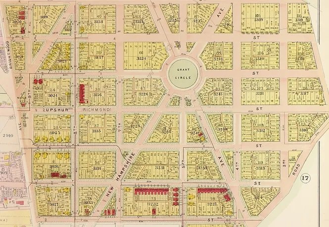
Baist insurance map from 1911 showing the development of the Petworth neighborhood around Grant Circle. (Library of Congress, Geography and Maps Division)
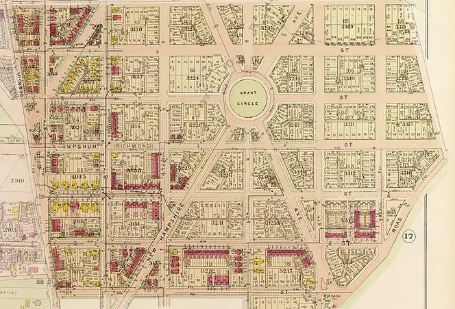
Baist insurance map from 1913 showing the development of the Petworth neighborhood around Grant Circle. (Library of Congress, Geography and Maps Division)
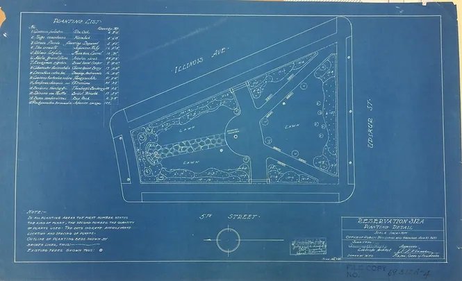
1920 planting plan for Reservation 312A. The same basic arrangement of trees and walks is still present and continues to define the cultural landscape. (Library of Congress, Geography and Maps Division)

Detail of 1990 Rehabilitation Plan for Grant Circle. (Library of Congress, Geography and Maps Division)
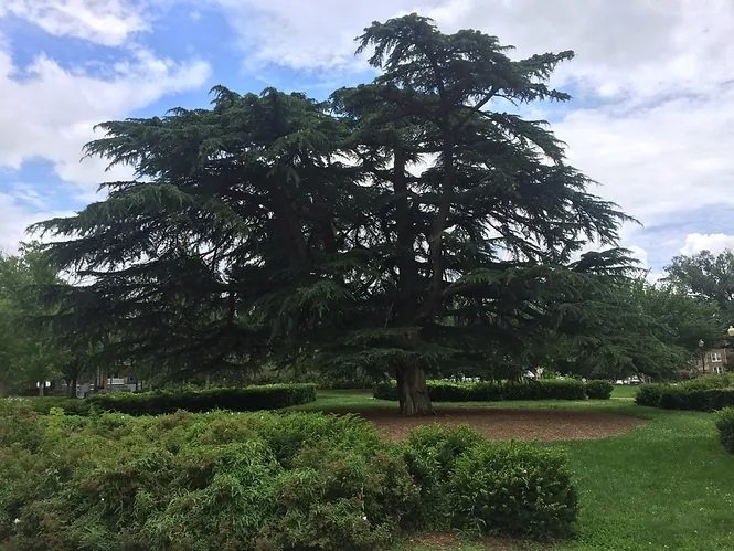
The historic Himalayan cedar, located at the center of Reservation 312. (Photo by Shannon Garrison)

Present circulation system at Grant Circle/Reservation 312, showing interior 10-foot wide circular sidewalk. (Photo by Shannon Garrison)

View from exterior of circle towards central Himalayan cedar. (Photo by Shannon Garrison)

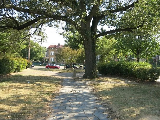
The historic American elm at Reservation 312A. (Photo by Shannon Garrison)

Curbing along interior of Grant Circle, Reservation 312. (Photo by Shannon Garrison)

Commemorative plaque at Grant Circle, Reservation 312. (Photo by Shannon Garrison)

Playground equipment at Reservation 312I. (Photo by Shannon Garrison)