Titanic Memorial Park
Washington, DC | 2019 - 2020
Cultural Landscape Inventory + Rapid Ethnographic Assessment Protocol
Project Team: Randall Mason, Molly Lester, Jacob Torkelson, Sarah Lerner, Xue Fei Lin, Katherine Payne
History
European development began in 1662 when the Young family was issued a 1,000 year lease for Cerne Abbey Manor (Carter et al. 2018: 21-24). The Young family built a plantation in the vicinity of the cultural landscape and cultivated the landing using enslaved labor. The cultural landscape was almost certainly ceded to federal control under the proprietors agreement of 1790, as it would later be planned by L’Enfant and Ellicott as a public right-of-way. In December 1793, a newly-formed group of real estate speculators, the Greenleaf Syndicate, became the first developers in the southwest quadrant to purchase lots and construct buildings.
During the Civil War, the cultural landscape served as the city’s main shipping and staging area for Union troops, their armaments, and supplies during the Civil War, owing to its waterfront location and its proximity to the Arsenal. After the Civil War, rapid postwar population growth necessitated the improvement of streets and public lands in the District. In the decades after the conflict, the Territorial Government and later, District of Columbia Board of Commissioners, constructed sewer and road improvements within the study area. As the southwest area of Washington, DC, urbanized in the second half of the 19th century, new streetcar lines began appearing around the city. During this time, tracks were installed in the center of Water Street SW and P Street. A significant flood event in 1881 forced Congress to reevaluate and conduct much-needed improvements to the Potomac River—and consequently the southwest waterfront (Gutheim 2006: 94). Construction of the Washington Channel (and later, East Potomac Park) protected the harbor and made it a deep-water port, sheltered from future silting and ice flows. By the early 1900s, much of the area surrounding the cultural landscape had been urbanized. Industrial businesses dotted the larger waterfront lots, and the cultural landscape served as the connective tissue between the various enterprises.
Between 1905 and 1930, the population of Southwest Washington, DC, decreased by a third, dropping from 35,000 to 24,000 residents amid decades of disinvestment. As a result, the Southwest rapidly gained the attention of civic reformers and federal authorities, who viewed the neighborhood as an eyesore and a slum (Smith 1988: 68). By the mid-20th century, calls for reclamation of the “blighted” Southwest would lead to fullscale clearance and redevelopment, and the displacement of thousands of residents, as part of one of the nation’s earliest and largest urban renewal projects (Ammon 2006:10-17). In 1945, Congress created the Redevelopment Land Agency (RLA) and tasked it with revitalizing “blighted” areas of Washington, DC, through acquisition, clearance, and redistribution of land for redevelopment. Redevelopment adjacent to the cultural landscape began in 1954. In 1960, architect Chloethiel Woodward Smith was hired by the Federal City Council to create a separate waterfront redevelopment plan for Project Area C. Her design called for an "urban edge" along the river consisting of a 20’-wide public park and was the impetus for the later development of the cultural landscape as a waterfront park.
Sometime between 1965 and 1967, the Commission of Fine Arts (CFA) selected landscape architecture firm Sasaki, Dawson & DeMay to develop the initial design for the study area. Under the direction of the Redevelopment Land Authority, Sasaki, Dawson & DeMay designed the park to incorporate landscape features with streamlined profiles and a Modernist material palette (including vegetation, structures, and small-scale features). During the design process, the CFA mandated that the design include Gertrude Vanderbilt Whitney’s Titanic Memorial sculpture, created in 1916, which had been displaced from its former site along the Rock Creek and Potomac Parkway. In 1967, the CFA approved the park design for the Titanic Memorial cultural landscape, and construction began in the following months.
Few changes have been made to the overall landscape of the Titanic Memorial park cultural landscape since the 1967-1968 design by Sasaki, Dawson & DeMay. The as-built 1968 design, including its spatial organization, land use, topography, circulation features, buildings and structures, views and vistas, and small-scale features, remains extant and legible in the park today.
Analysis + Evaluation
Landscape characteristics identified for the Titanic Memorial park cultural landscape are: land use; topography; spatial organization; circulation; views and vistas; vegetation; buildings and structures; and small-scale features.
Land Use: Land use refers to the principal activities conducted upon the landscape and how these uses organized, shaped, and formed the land. The publication of the L’Enfant Plan in 1791 set aside the reservation as a public right-ofway, although it would not be developed as such until later periods. Historically, the Titanic Memorial park cultural landscape was used for agricultural cultivation; this continued into the 19th century, until waterfront development overtook the Southwest. With the start of the Civil War in 1861, the cultural landscape served as the primary staging area for Union troops in the district. After this time, the cultural landscape continued to serve as a transportation corridor and staging ground for adjacent wharfs and businesses, including a trolley barn, lumber yard, ironworks, saloon, and armory. Urban renewal prior to the primary period of significance (1967-1968) cleared all development from the cultural landscape and removed any evidence of prior land uses. During the primary period of significance (1967-1968), the cultural landscape’s recreational and commemorative uses were established. Under the design of Sasaki, Dawson & DeMay, the cultural landscape was constructed as a small pass-through urban park, with active recreational uses in two play areas located at the north and south ends of the cultural landscape. The Titanic Memorial sculpture was also installed in the cultural landscape during this time, adding a commemorative use honoring the men who died on the Titanic. The current uses of the Titanic Memorial park cultural landscape are consistent with the primary period of significance, and the cultural landscape therefore retains integrity with respect to land use.
Topography: Topography refers to the three-dimensional configuration of the landscape surface, characterized by features such as slope, articulation, orientation, and elevation. Until the mid-19th century, the cultural landscape comprised sporadically improved shoreline consisting of scattered wharfs, limited seawalls, and steeply sloping shoreline bluffs. The first attempts to establish a uniform bulkhead and seawall began in the first few decades of the 20th century. Urban renewal efforts in the 1960s leveled the park site, graded the topography evenly, and established a uniform seawall defining the western edge of the cultural landscape. The park was formally graded and developed during the primary period of significance (1967-1968). During this time, Sasaki retained the generally flat topography that was created earlier in the 1960s, and established stepped concrete berms and recessed stepped play areas. The topography of Titanic Memorial park is consistent with the primary period of significance, as no change has been made to the cultural landscape’s topography since this time. As such, the cultural landscape’s topography retains integrity.
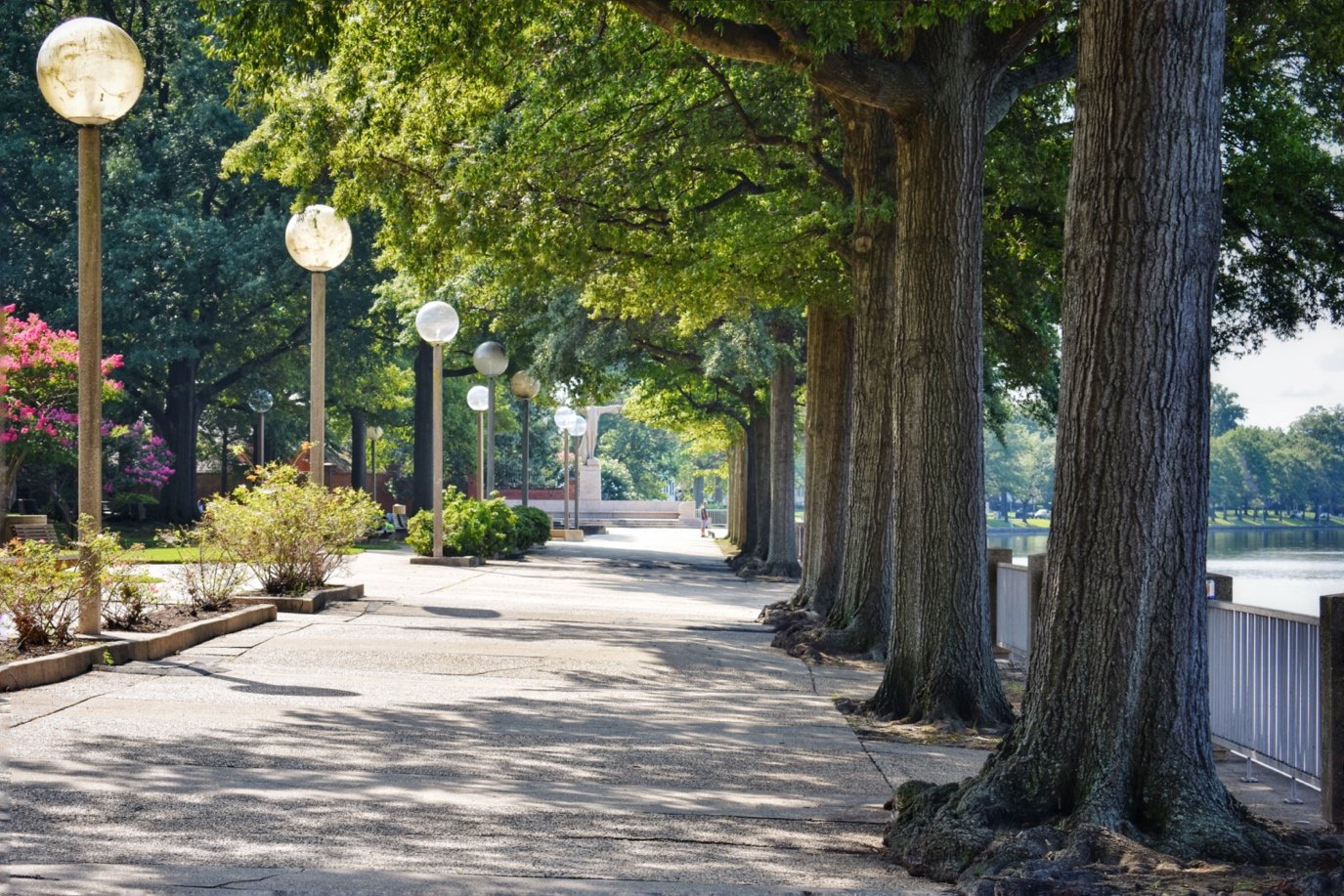
Spatial Organization: A cultural landscape’s spatial organization refers to the three-dimensional organization of physical forms and visual associations in the landscape, including articulation of ground, vertical, and overhead planes that define and create spaces. Prior to the primary period of significance (1967-1968), the cultural landscape was organized as a series of three streets: 6th Street SW, Water Street SW, and P Street SW. These were closed between 1966 and 1967, and removed to form a new and continuous open space. The 1967 Sasaki design of Titanic Memorial park formed an L-shaped park organized in three parts based on the routes of the former rights-of-way (see Figure 46). Sasaki also devised two play areas anchoring the north and south ends of the cultural landscape that remain extant today. The entire design scheme culminated in the siting of the Titanic Memorial sculpture in a large plaza at the southern end of the cultural landscape, which remains in the same location. These spaces are linked by tree-lined promenades, lined with uniform small-scale features. The spatial organization established by Sasaki during the primary period of significance is identical with landscape conditions at the site today. The cultural landscape therefore retains integrity of spatial organization.
Circulation: Circulation is defined by the spaces, features, and applied material finishes that constitute systems of movement in a landscape. The cultural landscape historically consisted of public streets prior to the primary period of significance (1967-1968). These streets were closed between 1966 and 1967 for the creation of a waterfront park. Sasaki designed a linear pass-through park whose design relied heavily on circulation features. Sasaki divided the park into three sections based on the former streets in the cultural landscape and constructed treelined promenades through each section. These walkways featured alternating bands of rough and smooth aggregate concrete. Sasaki also designed steps and ramps to encircle the irregularly-shaped play areas on the north and south ends of the cultural landscape; these features are extant today. The existing conditions at the Titanic Memorial park cultural landscape are consistent with the circulation features in place by the end of the primary period of significance (1967-1968). The circulation features in Sasaki’s plan remain clearly legible today, and the Titanic Memorial park cultural landscape retains integrity with respect to circulation.
Views and Vistas: Views and vistas are defined as the prospect afforded by a range of vision in the landscape, conferred by the composition of other landscape characteristics and associated features. The cultural landscape’s views and vistas are subject to the conditions of its topography, surrounding vegetation, and the buildings and structures in its vicinity. Until the 19th century, the cultural landscape likely had limited views due to its relatively low elevation (compared with the topography closer to Rock Creek, for example), beyond its expansive views of the Potomac River to the west. However, beginning in the late-18th century, it did enjoy a view north/northwest to the historic Young estate and wharf. The cultural landscape likely also featured views of the Greenleaf Syndicate’s developments to the east. By the late 19th and early 20th centuries, the cultural landscape likely enjoyed views of the new Washington Barracks (formerly the Arsenal), the 7th Street Powerhouse (P and Water Streets SW), and East Potomac Park. However, by the mid-20th century, Southwest urban renewal efforts would dramatically change the views from the cultural landscape. New high-rise developments around the cultural landscape replaced extant structures and featured prominently in the views available from the cultural landscape. During the primary period of significance (1967-1968), landscape architect Hideo Sasaki designed the cultural landscape to feature views of adjacent landmarks, and most notably, of the Washington Channel to the west. The Titanic Memorial park cultural landscape retains external views consistent with the primary period of significance, including historic views of nearby landmarks such as Fort McNair, the Washington Channel, East Potomac Park, and adjacent high-rise developments. The cultural landscape also retains internal vistas along axial walkways consistent with the primary period of significance, including most notably, views toward the Titanic Memorial sculpture. As a result, the Titanic Memorial park cultural landscape retains integrity of views and vistas.
Vegetation: Vegetation features are characterized by the deciduous and evergreen trees, shrubs, vines, ground covers and herbaceous plants, and plant communities, whether indigenous or introduced in the landscape. Little is known about the cultural landscape’s vegetation prior to the mid-20th century. The only known plantings prior to the primary period of significance include limited plantings of Buttonwood trees (Platanus occidentalis) and Elms (Ulmus) along the edges of the former streets. During the primary period of significance (1967-1968), the cultural landscape was redesigned. The new vegetation plan incorporated the few remaining extant trees, and new plantings were added according to a Modernist planting palette and pattern. Vegetation added during the primary period of significance was limited to plants with high-canopy trees and low-profile shrubs such as Willow Oak (Quercus phellos), Star Magnolia (Magnolia stellata), Hopa Crabapple (Malus x 'Hopa), and Sourwood trees (Oxydendrum arboreum). The cultural landscape’s vegetation is generally consistent with the primary period of significance, as vegetation features typically have been replaced with similar species. The Titanic Memorial park cultural landscape therefore retains integrity with respect to vegetation.
Buildings and Structures: Building features refer to the elements primarily built for sheltering any form of human activities; structures refer to the functional elements constructed for other purposes than sheltering human activity. Historically, the cultural landscape featured numerous buildings and structures prior to the primary period of significance (1967- 1968). These were all associated with maritime development and included wharfs, warehouses, docks, and boathouses. Urban renewal efforts prior to the primary period of significance (1967-1968) cleared all buildings and structures from the cultural landscape and established a uniform seawall and bulkhead along the Washington Channel. As part of the 1967-1968 Sasaki design, the cultural landscape included a series of concrete structures throughout the cultural landscape. These included stepped and recessed concrete walls adjacent to and composing the play areas, as well as low knee walls and planting bed structures throughout the cultural landscape. Most notably, the Titanic Memorial sculpture was created during the secondary period of significance (1916-1930) and added to the cultural landscape during the primary period of significance (1967- 1968) as a central element of the design. The cultural landscape retains all of these structures that date to the periods of significance and therefore, retains integrity with respect to buildings and structures.
Small Scale Features: Small-scale features are the elements that provide detail and diversity, combined with function and aesthetics, to a landscape. Little is known about the cultural landscape’s small-scale features prior to the primary period of significance (1967-1968), but these likely included typical streetlights and curbing, and features associated with maritime uses. These features were removed prior to the primary period of significance (1967-1968). Under the Sasaki design, new small-scale features included modern trash cans, drinking fountains, benches, lighting, bollards, planters, and railings. Limited non-contributing small-scale features have been added to the cultural landscape since the periods of significance, including two types of circular concrete planters, but these features do not detract from the cultural landscape’s significance. The Titanic Memorial park cultural landscape therefore retains integrity of small-scale features.

By the 20th century, an electric streetcar line passed through the cultural landscape along Water Street SW and P Street SW, terminating in the car barn and powerhouse located at the corner of those two streets. The area also featured several wharfs and industrial businesses such as the Charles White & Co. foundry and the T. R. Riley lumber yard. By 1903/1904, residential development had increased and there were few vacant lots in the vicinity of the cultural landscape. The boundaries of the cultural landscape are shown with a black dashed line (Excerpts from Baist 1903; Sanborn 1904, Library of Congress)

Preliminary sketches by sculptor Gertrude Vanderbilt Whitney were selected and approved for further development by the Commission of Fine Arts in 1913; however, Congressional approval of the Titanic Memorial would not come until 1917. Whitney’s design featured a semi-nude male figure on a pedestal with outstretched arms, recalling a cruciform. (Box 32, Folder 19, Gertrude Vanderbilt Whitney Papers, American Archive of Art)

The 1925 Rivers and Harbors Act authorized the Army Corps of Engineers to prepare the first redevelopment plan for the southwest waterfront. The plan called for the elimination of existing wharfs and docks, in favor of uniformly oriented piers and level pierhead lines. The plan also called for the improvement of Water Street SW as a tree-lined boulevard with a median that separated a service street with streetcars from a waterfront boulevard. (Excerpts from “Proposed Development of Washington Channel Waterfront,” ETIC_WEPO_801_125486_[id27207], NCA, NPS)

The Titanic Memorial park cultural landscape was one of 7 parks proposed for the Southwest Urban Renewal Area Project C. Construction of park #6 began in 1967 and was the first of the new parks to be built. (Doc 04, Southwest Waterfront Park Files, National Capital Area, NPS).

Panorama of the cultural landscape looking to the southwest. The 1967-1968 Sasaki design created a series of raised concrete berms and recessed play areas (left), in addition to the flat topography of the cultural landscape throughout. The western edge of the park (right) consists of steep seawall. (Photo by CLI author, 2019)

Examples of historic structures that were installed during the primary period of significance (1967-1968): (A) planting bed structures along the NW/SE walkways; (B) low knee walls flanking the seating areas along the O Street SW walkways; (C) concrete stairs, walls, and steps in the south play area; (D) the Titanic Memorial sculpture located at the southern end of the cultural landscape. (Photos by CLI author, 2020).
REAP Summary Observations
Our team spent a year studying the Titanic Memorial Park, building an understanding of both its history and its current value for the community that surrounds it. We conducted extensive archival research to understand the landscape as it took shape over several centuries, and we undertook a rapid ethnographic assessment to learn how that landscape is used and shaped by park visitors today. Based on this research, we offered some overarching observations:
People are invested in this park. We received over 350 responses to our online stakeholder survey, with very little promotion. Several respondents made extra efforts to follow up by email, sharing additional observations and, in many cases, their personal photographs of the park. It is clear that this park has a broad and loyal following; people care deeply about the past, present, and future of this space.
For some community members, the Titanic Memorial sculpture is key to their stake in this park. For others, it is incidental, irrelevant, or even a drawback. The sculpture is an obvious landmark in this park, which draws its name from the memorial in its midst. Yet, the sculpture occupies a strange place in the landscape and the public experience of this park, as its early- 20th century design contrasts with the Mid-Century Modernist landscape that surrounds it (despite the fact that the Modernist landscape was designed to host the sculpture). The memorial is a destination for many stakeholders; they discovered the park by way of the sculpture, and care first and foremost about the site’s association with the sinking of the Titanic. For many others, though, they enjoy the park independent of the memorial; the sculpture does not factor into their stake in this park at all. The crowds that it draws for tours and special commemorative events may even detract from their experience of the park.
The park has obscure boundaries and, in turn, a vague identity. The park connects with several other parks and green spaces in southwest Washington, DC. The continuity between these spaces is an asset for community members, but it does present challenges for the stewardship and identity of Titanic Memorial Park. These indeterminate boundaries introduce some conflicts over appropriate uses, which vary based on public/private ownership, and ownership is not always clear. It also means that the Titanic Memorial Park does not have its own clear identity, independent of (and in relation to) adjacent green spaces. The name “Titanic Memorial Park” is not articulated anywhere within the landscape, and as a result, is not familiar to all park visitors.
The community considers this park to be a hidden gem. The phrase “hidden gem” was used eleven times in online survey responses, without any prompting from our survey questions. The park is nestled along the waterfront, screened by the adjacent high-rise developments, Fort McNair, and the Southeast Freeway. This screening effect can have the negative effect of isolating the park in Southwest DC. However, it does have a positive effect as well: many people consider this park to be a delightful “discovery” (another word that emerged several times in our survey), whether they stumbled on it for the first time in the past year, or first encountered it several decades ago.
This park presents a rare opportunity for full accessibility to the waterfront. The landscape design’s wide walkways link the street grid’s sidewalks with the waterfront, and community members value this accessibility.
Stakeholders value the landscape design, but desire repairs. Park visitors appreciate the character of the landscape design. However, certain aspects of the park (e.g. pavers) have suffered from deferred maintenance, and detract from the appearance and experience of the park.
...But community members prioritize repair over a full redesign of the park. Park users expressed general support for the landscape design, and would prefer to see minor maintenance issues addressed, rather than a major redesign of the landscape.
The Friends of the Titanic Memorial Park (FOTM) presents an opportunity for ongoing engagement and active collaboration with community members. To begin where we started: people are invested in this park. This grassroots volunteer group has been able to harness some of that loyalty and contribute in meaningful, tangible ways to the stewardship of the park. FOTM’s leaders know how to communicate and coordinate with the National Park Service (even if such collaborations present occasional challenges for both FOTM and NPS). Titanic Memorial Park has reaped the benefits of this public-private partnership, and will continue to do so for as long as FOTM and NPS remain invested in this collaboration.