Virginia Avenue NW
Washington, DC | 2018 - 2019
Cultural Landscape Inventory
Project Team: Randall Mason, Shannon Garrison, Jacob Torkelson, Ashley Losco
History
The Virginia Avenue NW Cultural Landscape consists of fourteen small park reservations located along Virginia Avenue NW, between 18th Street NW and New Hampshire Avenue NW, from southeast to northwest: Reservations 110 (Artigas), 383 (Bolivar), 384 (Pan American Annex), 108, 378 (Federal Reserve Annex), 106 (San Martin), 105 (Edward J. Kelly Park), 104, 103, 720 (Galvez), 101, 99, 98, 134 (Juarez). These reservations are managed by the National Park Service, National Mall and Memorial Parks.
—
Between 1608 and 1790, Europeans replaced Native Americans as the main inhabitants of land that would eventually become Washington, D.C. As European immigration increased, established Native American settlements were abandoned or taken by force. Forests were cleared to make way for agriculture as European-born subsistence farmers began to plant for profit.
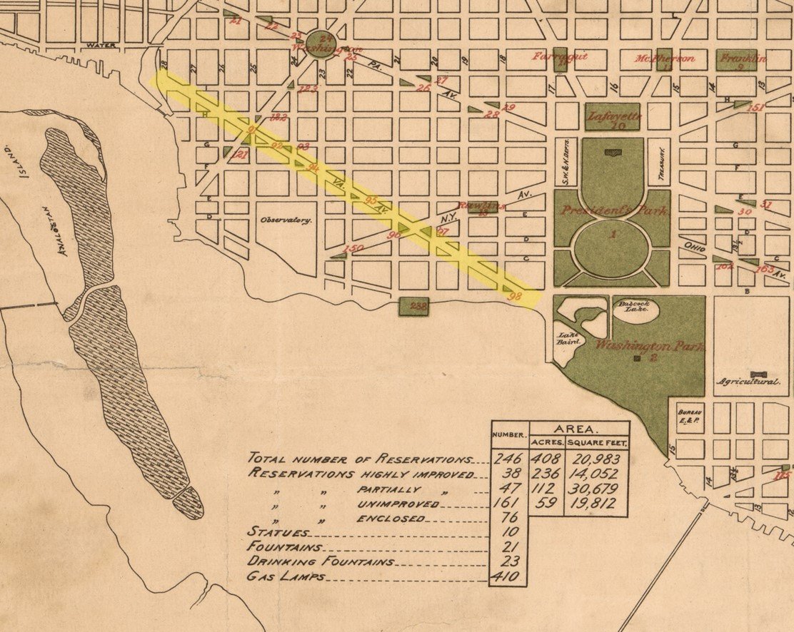
Major Pierre Charles L’Enfant, a French artist and engineer, who had formed a friendship with George Washington while serving in the Revolutionary War, requested the honor of planning the new capital. His final design encompassed approximately 6,111 acres. The fact that the area was largely undeveloped gave the city’s founders the unique opportunity to create an entirely new capital city. On L’Enfant’s original plan, Virginia Ave NW stretched northwest, at an angle of 136 degrees, from a riverside plaza along the mouth of the Tiber Creek to a circle on the west bank of Rock Creek, in present-day Georgetown.
No known development of either Virginia Ave NW, or any of its small parks, occurred in the early 19th century. Land for the future Virginia Ave NW had been cleared, but was unpaved and in places, still underwater. Albert Boschke’s 1857 map shows approximately 15 buildings, likely all residential, scattered along Virginia Avenue NW. The period between 1870-1901 saw the construction of a number of small parks that were first designed as part of the L’Enfant Plan. Historic photos show the eastern half of Virginia Avenue NW was largely vacant, and the park reservations east of 20th Street NW not yet clearly defined.
During the 1930s, the southern half of Virginia Avenue NW saw its first large-scale development, as the area was included as part of the Northwest Rectangle, and a number of federal agencies relocated their headquarters to either side of the avenue. New building on or near Virginia Avenue NW included the Public Health Services Building (now Interior Department South), the Department of the Interior Building, the Federal Reserve Building (now the Marriner S. Eccles Building), and the State Department’s Department of War Building. There is no documentation that any of Virginia Avenue’s small parks were redeveloped as a result of the Northwest Rectangle project; photos from the period and NPS survey forms suggest that they continued to be treated simply and were minimally landscaped.
The period from 1947 to 1977 saw a number of significant changes to Virginia Avenue NW. Between 1950 and 1976, four statues devoted to Latin American Revolutionaries were installed along the avenue, at reservation 110 (Artigas), 383 (Bolivar), 106 (San Martin), and 134 (Juarez). Another statue, dedicated to Spanish general Bernardo de Galvez, a participant in the American Revolution, was erected at reservation 720. An additional statue, the Discobolos, was installed at Reservation 105 (Edward J. Kelly Park) in 1956. Reservation 106 (San Martin) was temporarily destroyed during construction of the E Street Expressway, but was redeveloped and expanded in 1976. Highway construction also resulted in the creation of a new reservation, Reservation 720 (Galvez), in the 1960s, after completion of a freeway offramp. Additional developments along Virginia Avenue NW included the 1974 completion of the Federal Reserve Annex, located south of Reservation 378.
The past 40 years have seen relatively few changes along Virginia Avenue NW. However, several spaces immediately adjacent to the avenue have been proposed as sites of future museums or national memorials, no plans for major new developments are currently underway. In the meantime, the National Park Service has continued regular maintenance at individual small parks, and completed rehabilitation projects at several reservations, including Reservation 106 (San Martin), 383 (Bolivar), and 134 (Juarez). As of the completion of this report, a Federal Reserve-managed restoration was underway at Reservation 378 (Federal Reserve Annex).
Analysis + Evaluation
Landscape characteristics identified for Virginia Avenue NW are: location; land use; topography; spatial organization; circulation; cluster arrangement; views and vistas; vegetation; small scale features and constructed water features.
Land Use: Throughout its history, the Virginia Avenue NW Cultural Landscape has consistently maintained a number of original uses, all designed as part of L’Enfant’s original plan. These include transportation, recreation, commemoration and political use. Subsequent periods of significance resulted in the redesign of the avenue’s small parks to accommodate new modes of thinking regarding recreation, changing modes of transportation and shifting political priorities. These developments were in keeping with, and expanded upon, L’Enfant’s original intentions for Virginia Avenue NW. As a result, the landscape retains integrity to all three periods of significance.
Topography: Throughout its history, the topography of Virginia Avenue NW has been relatively flat. This is in keeping with the natural topography of the land that the avenue was built on, and the L’Enfant Plan for streets and open spaces throughout the city of Washington. Parks were first graded as part of their initial period of constructions, from 1899 to 1912. Slight topographical changes to the landscape via raised plazas, terraces and slightly sloped lawns, were designed or introduced during the third period of significance. These changes were relatively minor and did detract from the original impression of a generally flat streetscape. They are still, however, considered significant. As such, the landscape retains integrity to all three periods of significance.
Spatial Organization: All small parks designed as part of the original L’Enfant Plan had highly developed, geometric relationships to other L’Enfant-designed spaces, such as streets and avenues, surrounding small parks, seats of government and planned commemorative sites. Spatial organization of Virginia Avenue NW consists of the centrally located avenue with small park reservations located on either side. Sightlines and direct connections between small parks and other designed elements, were defining organizing principles of the plan, and expressions of the Baroque city planning that inspired L’Enfant. These relationships were first established by the OPBG during the initial period of small park construction along Virginia Avenue NW, which lasted from 1899 to 1912. As a result, the landscape retains integrity of spatial organization to the first and second periods of significance.
In general, the spatial organization of individual reservations along the avenue dates to the third, midcentury period of significance (1950-1976), when many of the small parks were redesigned to accommodate statues, commemorative fountains or street/highway expansion and most Virginia Avenue small parks also retain integrity of spatial organization to the third period of significance.
Circulation: All the L’Enfant small parks are located within traffic rights-of-way, and as a result, city streets border the parks on all sides. The relationship of the reservations along Virginia Avenue NW, to the surrounding street grid, is a fundamental element of the L’Enfant Plan and an integral part of the circulation pattern L’Enfant developed for the city as a whole. The OPBG defined this relationship during the second period of significance, when they built the small parks along Virginia Avenue NW, delineating them from surrounding streets with curbing and fencing. Virginia Avenue NW’s primary circulation system, designed during the first period of significance and built during the second, remains intact and the landscape retains integrity to this period.
As with spatial organization, the design of the circulation patterns present at individual reservations generally dates to the third period of significance, when these parks were redesigned around modern plazas, newly installed statues and commemorative water features. As a result, the circulation of Virginia Avenue NW also retains integrity to the third period of significance.
Cluster Arrangement: Clusters of rectangular and triangular open spaces along Virginia Avenue NW were designed during the first period of significance, as part of the L’Enfant plan, and built/expanded by the OPBG, during the second period of significance, The relationship of these small parks to one another is an expression of the L’Enfant Plan’s overall spatial organization, which established direct links and geometric connections between various elements. Despite various periods of redevelopment along the avenue which affected the location and layout of individual small parks, the current cluster arrangement retains integrity to the first period of significance. During the third period of significance, an additional cluster arrangement was designed for the avenue, consisting of the thematic arrangement of statues devoted to Latin American liberators, installed at small parks between 1950 and 1976. These statues are all extant and thus the landscape retains additional integrity to the third period of significance.
Views and Vistas: Vistas from small parks towards government buildings and monuments were a defining characteristic of the L’Enfant Plan and an important aspect in its overall spatial organization. These vistas were designed to connect smaller spaces with sites of national importance, binding the city together through a constant reminder of shared American values. The main sightlines designed for Virginia Avenue NW were views southeast, toward the Tiber Creek and National Mall and northwest to Georgetown. Additional views included sightlines down the street grid at F and G Streets NW, between Virginia Avenue NW and the Executive Mansion, as well as between planned open spaces, including reservations No. 4 and other open space along Virginia Avenue, New Hampshire and New York Avenues NW. Views between smaller parks, including circles, triangles and medians, further enforced Washington’s city plan, designed by L’Enfant as a reflection of America itself. The construction of the Virginia Avenue NW parks during the second period of significance established these planned views for the first time, and established additional ones, directed toward new monuments, like the Lincoln Memorial and the Washington Monument. While mid-rise development in the 20th century has obstructed some of these views, enough remain intact for the Virginia Avenue Cultural Landscape to retain integrity to the first and second periods of significance. Between 1950 and 1976, a number of views were introduced at individual reservations, framing newly installed statuary. As a result, several small parks also have integrity of views and vistas to the third period of significance as well.
Vegetation: Vegetation was not included as part of L’Enfant’s original design for open spaces in Washington. As part of the delineation and development of small parks in the early 20th century, the OPBG planted turf grass, shade trees and flowers in small parks along Virginia Avenue NW. Research for this CLI did not uncover any specific planting plans for these reservations, and no vegetation is believed to date to the second period of significance. Elements of landscape designs installed during the mid-century period of redevelopment along the avenue, including plant material and planting plans, are intact. Thus, the Virginia Avenue NW landscape retains integrity to the third period of significance.
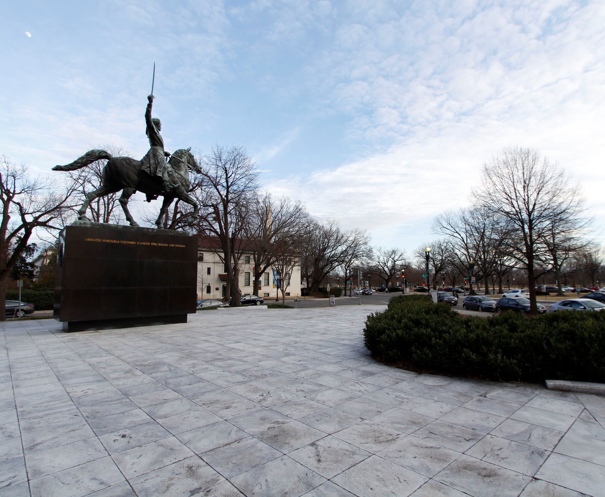
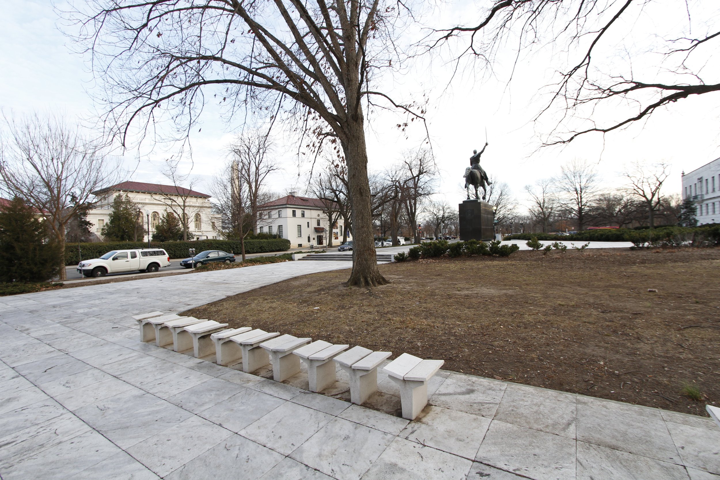
Small Scale Features: Small scale features found along Virginia Avenue NW include five statues, installed in five small park reservations during the third period of significance, and a number of lampposts, benches, built in seating, trashcans and curbing, designed as part of redevelopment or redesigns of reservations dating to the same 1950 to 1976 period. Many of these features were specifically designed as part of larger plazas and exhibit characteristics of modern landscape design, such as the use of simplified, geometric forms and lack of ornamentation. The statues depict a number of “liberators,” who helped secure independence throughout South and North America. These include, from SE to NW: General Jose Gervasio Artigas, Simon Bolivar, General Jose de San Martin, Bernardo de Galvez, and Benito Juarez. With the exception of the San Martin statue, which dates to 1924, all of the statues were cast between 1950 and 1976. Several are copies of originals located in South America. A sixth statue, a 1956 copy of an ancient Greek Discus Thrower by Myron, is located in Reservation 106 (San Martin) and was a gift from Italy. The statues and other small scale features, described in detail below, retain integrity to the third period of significance.
Constructed Water Features: Two large decorative fountains, dating to the third period of significance are located at reservations 383 (Bolivar), and 378 (Federal Reserve Annex) along Virginia Avenue NW. These fountains were designed as part of the redevelopment of the southeast half of the avenue, as an enclave of government offices. The 1959 redesign of Reservation 383, as Simon Bolivar Plaza, included the construction of an asymmetrical blue tile pool. Six jets spouting water high into the air represented the six countries liberated by Bolivar. In 1974, construction of a new Federal Reserve annex building on Reservation 378 included the design of a circular memorial fountain dedicated to Robert Latham Owen, co-sponsor of the Federal Reserve Act. Landscape architect George E. Patton designed the modernist fountain as a complement to the new building. Both of these fountains are still present and retain integrity to the third period of significance.

Plan for the City Intended for the Permanent Seat of the Government of the United States, showing Virginia Avenue NW with open spaces highlighted. Pierre Charles L’Enfant; US Coast and Geodetic Survey and United States Commissioner of Public Buildings, 1791. Library of Congress.

Map of Washington City, District of Columbia. Albert Boschke, 1857. Library of Congress.

City of Washington Statistical Map Showing Street Pavements. F.V. Greene and William T.O. Bruff, 1880. Library of Congress.

City of Washington Statistical Map Showing Shade Trees. Virginia Avenue NW is lined with poplar trees. F.V. Greene and William T.O. Bruff, 1880. Library of Congress.
Map of the City of Washington Showing the Public Reservations Under Control of the Office of Public Buildings and Grounds. Virginia Avenue Reservations highlighted. William Forsyth, A.F. Rockwell, 1884. Library of Congress.

Aerial view of Virginia Avenue from Washington Monument, 1890 (Gelman Library, GWU). The photograph likely dates to 1894 or 1895 as the Burnes Cottage is no longer in the photograph with a known removal date of 1894.

1901-1902 artistic rendering of McMillan Plan model, from Worthy of a Nation: Washington, DC from L’Enfant to the Capital Planning Commission, Frederick Guttheim and Antoinette Lee, 2006.

Undated photo, taken circa 1912, showing Virginia Avenue NW. Photo taken from Washington Monument. Detroit Publishing House.

Photo from OPBG survey, showing reservation no. 98, a small park at the intersection of Virginia Avenue, 25th and G Streets NW. 1927. The gas works are visible to the west. NPS Land Files.

Reservation 383 (Bolivar), photographed in 1938. NPS Historic Negative Collection. Image from Department of Interior National Register Nomination.
Seating designed for Bolivar Park.
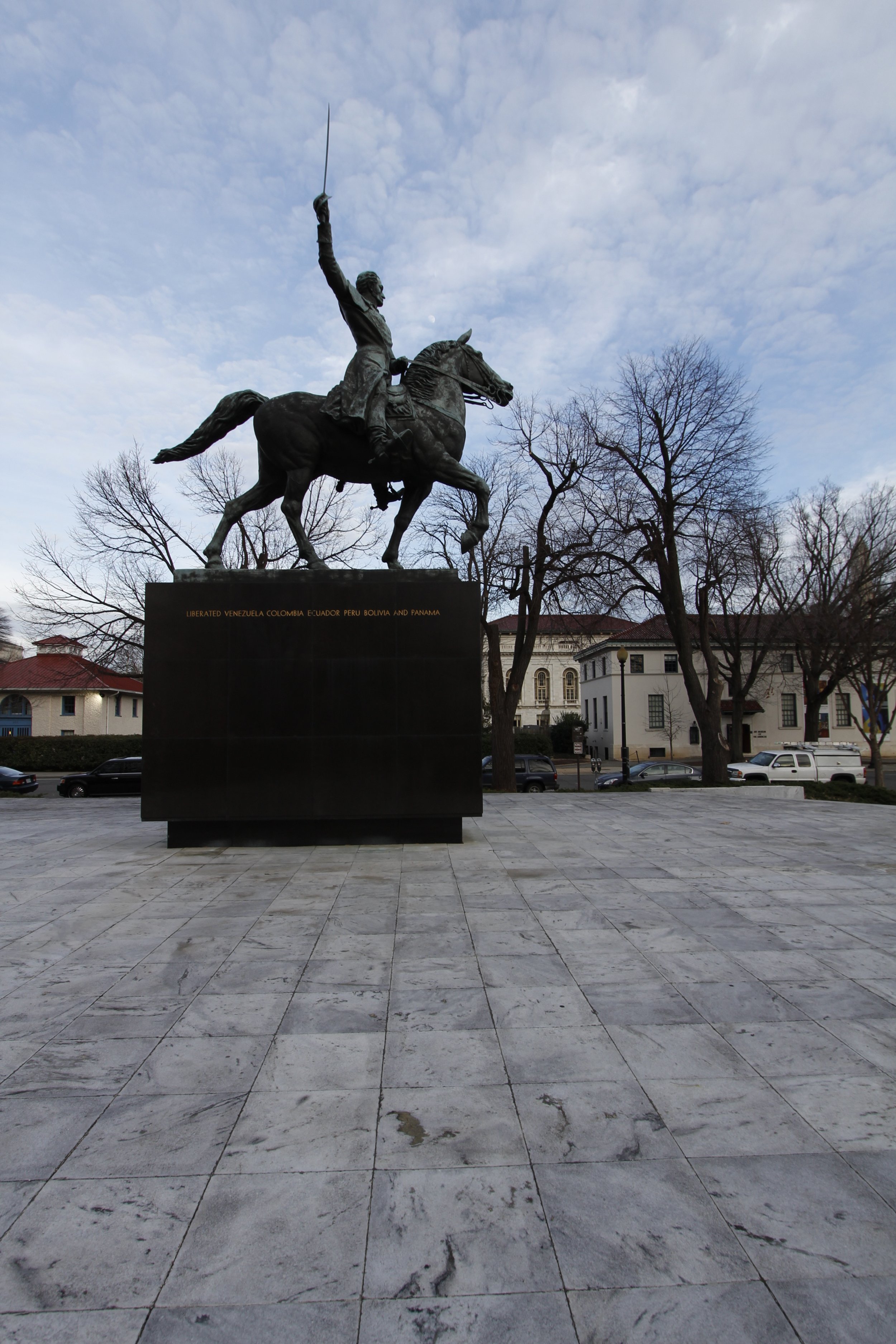
One of the six statues of Latin American revolutionaries, honoring Simon Bolivar and located at Reservation 383 (Bolivar).

Seating designed for San Martin Plaza.

One of the six statues of Latin American revolutionaries, honoring Jose de San Martin and located at Reservation 106 (San Martin).

George Patton’s lampposts at Federal Reserve Annex.

Mass plantings of grasses at Reservation 378 (Federal Reserve Annex).
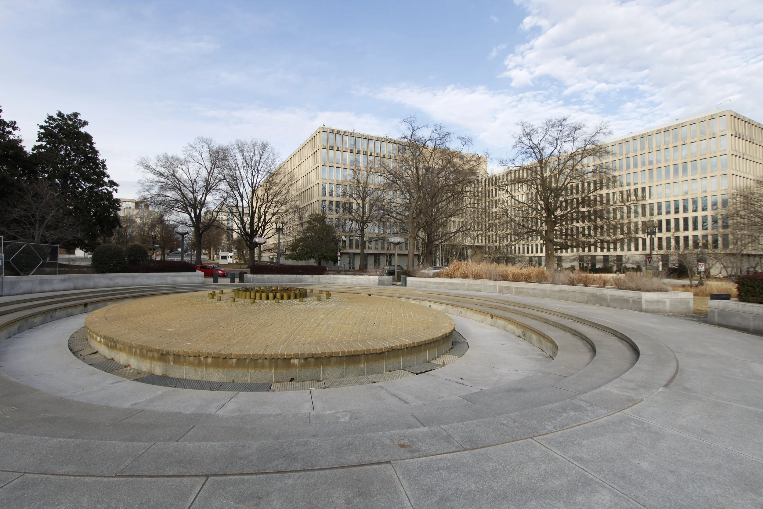
Robert Latham Owen Fountain at Reservation 378 (Federal Reserve Annex)
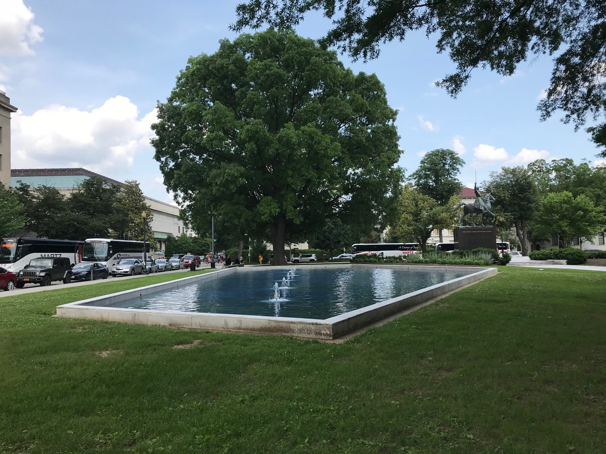
Bolivar pool at Reservation 383 (Bolivar, right).